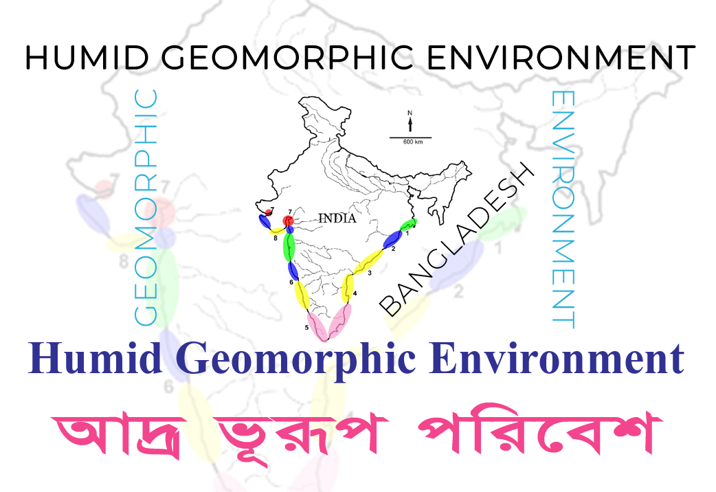
Humid Geomorphic Environment , The humid geomorphic environment refers to landscapes and landforms shaped by various geological processes under a relatively high moisture regime. These environments are typically found in regions with abundant rainfall or high levels of humidity. They are distinct from arid or semi-arid geomorphic environments, where water scarcity is a dominant factor.
Humid Geomorphic Environment
Characteristics of the humid geomorphic environment include:
- Fluvial Processes: Rivers and streams play a crucial role in shaping the landscape in humid environments. High and regular rainfall leads to a significant volume of water flow, resulting in erosion, transportation, and deposition of sediments. The extensive network of rivers often leads to well-developed drainage patterns.
- Weathering and Erosion: The frequent moisture and humidity enhance chemical weathering processes, breaking down rocks and minerals. Additionally, mechanical weathering processes like freeze-thaw cycles and root action are more pronounced due to higher water content. Consequently, erosion rates can be relatively high.
- Karst Landforms: In areas with soluble bedrock (such as limestone or gypsum), the humid environment can lead to the formation of distinctive karst landforms. These include sinkholes, caves, and limestone pavements, created by the dissolution of the rock by acidic water.
- Hills and Valleys: The combination of weathering, erosion, and fluvial processes often results in a diverse landscape of hills and valleys. Slopes may be relatively steep, especially in areas with resistant rock formations.
- Mass Wasting: The high precipitation rates can lead to instability on slopes, triggering mass wasting processes like landslides and debris flows.
- Glacial Landforms (in certain regions): In higher elevations or polar regions, humid environments can also support glaciers, which create characteristic glacial landforms such as cirques, moraines, and U-shaped valleys.
- Lakes and Wetlands: The presence of numerous water bodies, including lakes, ponds, and wetlands, is a characteristic feature of humid geomorphic environments. These water bodies are often important habitats for diverse flora and fauna.
- Soil Development: The high moisture content facilitates soil formation, and well-developed soils are common in humid regions. The type of soil varies depending on factors like parent material, vegetation, and drainage conditions.
- Vegetation: Humid geomorphic environments usually support lush vegetation due to the availability of water. Tropical rainforests and temperate deciduous forests are examples of characteristic ecosystems found in such areas.
- Human Impact: Humid geomorphic environments have historically been attractive for human settlement due to their fertile soils and ample water resources. As a result, these regions often experience significant human impact through agriculture, deforestation, and urbanization.
Running Water and Streams: Origin & Evolution of rill, gullies, streams
Running water plays a crucial role in shaping the Earth’s surface, and the origin and evolution of rills, gullies, and streams are intimately connected to the erosional processes of fluvial systems. Here’s a brief overview of how these landforms form and evolve:
1. Rills: Rills are small, shallow channels that form as a result of the concentration of water flow and the erosive action of water on the soil surface. They often appear after heavy rainfall or snowmelt when water starts to flow over the ground. The process of rill formation involves:
- Sheet Erosion: Initially, water flows over the surface as a thin sheet, gradually eroding the soil particles and creating tiny depressions or irregularities.
- Concentration of Flow: As these depressions deepen and enlarge, the water flow becomes more concentrated in specific pathways, forming miniature channels called rills.
- Erosion and Enlargement: The flowing water in the rills continues to erode the soil, deepening and widening the channels.
- Rills are commonly found on agricultural fields and bare soils, especially in areas with gentle slopes. If not managed properly, rills can evolve into larger gullies.
2. Gullies: Gullies are deeper and wider channels than rills, characterized by more significant erosion and a more distinct pathway. The formation and evolution of gullies involve several stages:
- Initiation: Gullies often originate from pre-existing rills. When rills become sufficiently deep and wide due to continued water flow and erosion, they can transform into small gullies.
- Headward Erosion: Gullies grow by headward erosion, where water at the gully’s headcuts into the soil and bedrock, extending the channel upslope.
- Downcutting and Widening: The flowing water in the gully continuously erodes the channel’s bottom, deepening the gully further. Erosion on the gully’s sides also contributes to its widening.
- Bank Erosion: The eroded material from the gully’s banks is transported downstream, further contributing to the widening of the gully.
- Gullies are often found in regions with moderate slopes and are typical in areas with poor vegetation cover and insufficient soil protection.
3. Streams: Streams are larger water channels that result from the continuous evolution of rills and gullies. As gullies widen and deepen over time, they may coalesce to form more extensive channels known as streams. The formation and evolution of streams involve several processes:
- Channelization: As gullies grow and merge, they form interconnected channels that become more stable and well-defined.
- Incision: The continuous flow of water leads to the downcutting and incision of the streambed, further deepening the channel.
- Lateral Erosion: Streams also undergo lateral erosion, widening the channel and altering the surrounding landscape.
- Meandering: Over time, streams may develop meandering patterns, where the water flow swings from side to side, shaping the streambanks.
- Valley Formation: As streams continue to erode the landscape, they create valleys and contribute to the overall geomorphology of the region.
- Streams are essential components of drainage systems and play a vital role in transporting water and sediment across the landscape.
In summary, rills, gullies, and streams are stages of landform development in fluvial systems. They illustrate the continuous erosional processes of water as it moves over the land, shaping the surface and creating distinctive features in the landscape. Proper land management and conservation practices are essential to prevent excessive erosion and mitigate the formation of gullies, which can have significant environmental impacts.
Process of Valley Development; Hydraulic geometry, longitudinal and cross profile
A valley is a low-lying, elongated depression or landform between hills or mountains, typically carved by the erosional action of water, such as rivers or streams, over a long period. It is characterized by a V-shaped cross-section in its upper reaches, transitioning to a wider and more open shape in the lower parts. Valleys are important features in landscapes and often serve as drainage pathways for water flow.
The process of valley development is a complex and dynamic interplay of various geomorphic processes, primarily driven by the erosional action of running water, especially rivers and streams. Valleys are elongated depressions in the Earth’s surface, and their formation involves both erosion and sediment transport. The evolution of valleys is influenced by factors such as geology, climate, tectonics, and vegetation cover. Let’s explore the key processes and aspects of valley development:
1. Erosion and Sediment Transport: Running water is the primary agent of erosion in valley development. As water flows over the land, it erodes the underlying rock and soil through a combination of hydraulic action, abrasion, and corrosion. The eroded material is then transported downstream as sediment. The efficiency of erosion and sediment transport is influenced by factors such as water discharge, gradient, channel shape, and sediment load.
2. Hydraulic Geometry: Hydraulic geometry refers to the relationship between the characteristics of a river or stream (such as width, depth, and velocity) and the discharge (the volume of water passing a given point per unit of time). It describes how a river’s dimensions change along its course. Generally, as discharge increases downstream, the river’s width, depth, and velocity also increase. This is because more water requires a larger channel to accommodate its flow. Hydraulic geometry helps understand how rivers adjust their form and size to accommodate different flow rates and sediment loads.
3. Longitudinal Profile: The longitudinal profile of a river or stream refers to its elevation along its course from its headwaters to its mouth (where it joins another river or a larger body of water). The longitudinal profile typically exhibits several characteristic features:
Headwaters: At the uppermost part of the river, near its source, the slope is steep, and the flow is often faster due to the high gradient.
Gradient Changes: As the river flows downstream, the gradient usually decreases, leading to gentler slopes.
Valley Cross-Section: The shape of the valley cross-section also evolves along the longitudinal profile. In the upper reaches, the valley tends to be V-shaped, indicating the influence of vertical erosion. In the lower reaches, the valley is often wider and more open due to the lateral erosion and deposition of sediments.
Base Level: The lowest point to which a river can erode its bed is called the base level. It can be the ocean or a lake into which the river flows. The base level influences how rivers erode and shape their valleys.
4. Cross Profile: The cross profile of a river or stream refers to its shape and features as observed from a perpendicular perspective. The cross profile of a river channel is influenced by the balance between erosion and sediment deposition. Key features of the cross profile include:
Channel Width: The width of the channel varies depending on factors like water discharge and sediment load.
Thalweg: The thalweg is the line of maximum velocity in a river channel. It is typically located near the center of the channel.
Point Bars and Cut Banks: In meandering rivers, point bars (deposits of sediment) develop on the inner bends of meanders, while cut banks (erosional features) form on the outer bends.
Floodplains: In low-energy environments, rivers may develop floodplains, which are broad, flat areas adjacent to the main channel that get inundated during high flow events.
Valleys can take millions of years to form, and their evolution is subject to ongoing changes due to natural and human-induced factors. Understanding the processes involved in valley development is essential for managing and conserving these valuable landscapes.
- What do you mean by stream process? Discuss the characteristics of stream process and. (2016) (2018) (2021)
Stream processes refer to the various natural actions and movements of water in rivers and streams that shape the landscape and influence the flow of water and sediment within the stream system. These processes are an integral part of fluvial geomorphology, which studies the interactions between flowing water and the landforms it creates or modifies.Streams are powerful agents of landscape change, continuously shaping the land through erosion and deposition. Understanding these processes and their associated features is essential for studying the dynamics of river systems and managing the impact of streams on the surrounding environment.Key stream processes include:
1. Erosion: Erosion is the process by which running water removes and transports soil, sediment, and rock from the streambed and its banks. The three main types of erosion in streams are:
Hydraulic Action: The force of flowing water dislodges and loosens rock and sediment from the streambed and banks.
Abrasion: The scouring action of sediment-laden water wears away the streambed and banks, creating a smooth, polished surface.
Corrosion (Chemical Erosion): Slightly acidic water can dissolve certain types of rocks and minerals, contributing to erosion.
2. Transportation: Streams transport eroded materials, including rock fragments, sediment, and organic matter, downstream. The transportation of sediment occurs through three mechanisms:
Bed Load: Larger and heavier particles roll, slide, or bounce along the streambed.
Suspended Load: Smaller and lighter particles, like silt and clay, remain suspended in the flowing water.
Dissolved Load: Some materials dissolve in the water, carried in solution.
3. Sedimentation and Deposition: As the energy of the stream decreases, it loses its capacity to carry sediment, leading to sediment deposition. Deposition occurs when the stream’s velocity decreases, or if the volume of water decreases due to a decrease in discharge or entering a larger body of water like a lake or ocean.
4. Weathering: Weathering is the breakdown of rocks and minerals at or near the Earth’s surface due to physical, chemical, and biological processes. The resulting rock fragments and particles become susceptible to erosion by streams.
5. Channel Formation and Morphology: Streams shape their channels based on factors like the amount of water flowing (discharge), the size and type of sediment, and the slope of the land (gradient). These factors influence the width, depth, and shape of the stream channel.
6. Meandering and Braiding: Meandering refers to the sinuous curves that some streams develop due to lateral erosion and deposition of sediment. Braiding occurs in channels with multiple interconnected smaller channels due to abundant coarse sediment.
7. Flooding: Flooding is a natural process where streams overflow their banks, depositing sediment on adjacent floodplains. Floods play a vital role in shaping riverine landscapes and enriching the soil.
8. Delta Formation: When a stream enters a larger body of water, like a lake or ocean, sediment may accumulate at the mouth of the stream, forming a delta.
Understanding stream processes is essential for studying river dynamics, managing water resources, predicting flood events, and mitigating the impact of human activities on stream ecosystems. The continuous interplay of these processes shapes the physical characteristics of river systems, such as the formation of valleys, river terraces, alluvial plains, and other landforms.
Characteristics of Stream Processes in Tropical Humid Environments:
- High Precipitation: Tropical humid environments receive abundant rainfall throughout the year, leading to high water availability and continuous flow in streams. This consistent water supply enhances erosional and sediment transport processes.
- Intense Erosion: The combination of high rainfall and steep slopes in tropical regions leads to intense erosion. Erosion by running water carves out valleys, gorges, and canyons, transforming the landscape over time.
- Fast-flowing Streams: The high water volume and steep slopes in tropical regions result in fast-flowing streams. The velocity of water aids in the transport of sediment and can lead to turbulent flow in many sections of the stream.
- Lush Vegetation: Tropical humid environments are known for their dense vegetation cover, which contributes to the erosion process by stabilizing soil and reducing surface runoff. However, deforestation and land-use changes can increase erosion rates significantly.
- Meandering Rivers: In areas with lower slopes and abundant sediment supply, meandering rivers are common in tropical humid environments. These rivers create sinuous curves, shifting and shaping their channels through erosion and sediment deposition.
- High Sediment Load: The fast-flowing rivers in tropical regions carry a high sediment load, including sand, silt, and clay. These rivers often have a brownish appearance due to the large amount of suspended sediment.
- Seasonal Variation: While tropical regions generally have a consistent humid climate, some areas experience seasonal fluctuations in precipitation. This can lead to seasonal changes in streamflow and the formation of floodplains during heavy rainfall.
Depositional and Erosional Features of Streams in Tropical Humid Environments:
Erosional Features:
- Valleys: V-shaped valleys are common in the upper reaches of streams due to the dominance of vertical erosion.
- Waterfalls and Rapids: Differential erosion of more resistant rock layers can create waterfalls and rapids along the stream course.
- Gorges and Canyons: Over time, streams can carve deep gorges or canyons in the landscape through continuous erosion.
- Meanders: In low-gradient areas, streams may develop meandering curves as they erode the outer banks and deposit sediment on the inner banks.
Depositional Features:
- Floodplains: During heavy rainfall or seasonal floods, streams overflow their banks and deposit sediment on adjacent floodplains. These fertile floodplains are essential for agriculture.
- Meander Point Bars: In meandering rivers, sediment is deposited on the inside of bends, forming point bars.
- Alluvial Fans: In mountainous tropical regions, alluvial fans can form at the base of slopes where fast-flowing streams exit narrow valleys into broader plains.
- River Deltas: In coastal areas, where streams flow into the ocean, sediment may accumulate at the river mouth, forming river deltas.
- Levees: During floods, streams may deposit coarser sediment along their banks, forming natural levees that act as raised embankments.
In tropical humid environments, the interplay of erosion, transportation, and sediment deposition in streams shapes diverse and dynamic landscapes. The combination of high-water availability, steep slopes, and abundant sediment leads to unique erosional and depositional features that define these regions. Sustainable land-use practices and conservation efforts are essential to maintaining the health and ecological balance of streams in tropical humid environments.
- What is meant by stream flow? Classify stream flow in details and describe the characteristics of Each type of stream flow. Narrate how do you calculate stream velocity and discharge. (2016)
Stream flow refers to the movement of water in a river or stream, which is a vital component of the hydrological cycle. It involves the continuous flow of water downstream, driven by the force of gravity. Stream flow is essential for transporting water, sediment, nutrients, and various organisms, contributing to the ecological health of river ecosystems and supporting human activities such as agriculture, industry, and water supply.Stream flow can be classified into several types based on the flow pattern and characteristics:
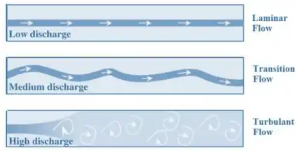
1. Laminar Flow: Laminar flow is a smooth and orderly flow pattern in which water moves in parallel layers or streams without significant mixing between them. It occurs when the stream’s velocity is relatively low and the water flows smoothly along a straight path. Laminar flow is more common in slow-moving or shallow streams. The flow is predictable, and there is minimal energy loss due to friction.
2. Turbulent Flow: is characterized by chaotic and irregular movement of water, with eddies and vortices forming in the stream. This type of flow occurs when the stream’s velocity is high or when there are obstructions in the streambed that disrupt the smooth flow. Turbulent flow is more energetic and leads to greater mixing of water layers. It is the dominant flow pattern in fast-moving or deep streams. Turbulent flow results in higher energy loss due to increased friction between water molecules.
3. Transitional Flow:Transitional flow is a combination of laminar and turbulent flow. It occurs in certain conditions when the flow velocity is at the critical point between laminar and turbulent flow.In transitional flow, some areas of the stream may exhibit laminar characteristics, while others show turbulent behavior.
Stream Velocity: Stream velocity is the speed at which water moves within a river or stream. It is influenced by factors such as the stream’s slope (gradient), the volume of water flowing (discharge), and the cross-sectional area of the stream channel. The velocity can vary at different points along the stream’s course, depending on the characteristics of the channel and the streambed.
Stream Velocity Calculation: Stream velocity (V) is the speed at which water moves within a river or stream. It can be calculated using the formula:
V = Q / A
Where: V = Stream velocity (in meters per second, m/s or feet per second, fps) Q = Discharge (volume of water passing a given point per unit of time, in cubic meters per second, m³/s or cubic feet per second, cfs) A = Cross-sectional area of the stream channel (in square meters, m², or square feet, ft²)
To calculate stream velocity, you need to measure the discharge (Q) and the cross-sectional area (A) of the stream at a specific location.The flow regime of a stream, whether laminar or turbulent, depends on the stream’s velocity and the conditions of the streambed. At low velocities, water tends to flow in a more orderly manner, resulting in laminar flow. As velocity increases, the flow becomes more turbulent, with chaotic and irregular movements. The transition from laminar to turbulent flow occurs at a critical velocity, which varies depending on factors such as the channel roughness and shape.
Stream Discharge: Stream discharge refers to the volume of water passing a given point in the stream over a specific period, usually expressed in cubic meters per second (m³/s) or cubic feet per second (cfs). Discharge is a crucial parameter for understanding a stream’s behavior and hydrology. It is affected by factors such as rainfall, snowmelt, groundwater contributions, and human activities such as water withdrawals and dam operations.
Stream Discharge Calculation: Stream discharge (Q) refers to the volume of water passing a given point in the stream over a specific period. It can be calculated using the formula:
Q = V x A
Where: Q = Stream discharge (in cubic meters per second, m³/s or cubic feet per second, cfs) V = Stream velocity (in meters per second, m/s or feet per second, fps) A = Cross-sectional area of the stream channel (in square meters, m², or square feet, ft²)
To calculate stream discharge, you need to measure the stream velocity (V) and the cross-sectional area (A) of the stream at a specific location.
Stream velocity and discharge play a crucial role in shaping riverine landscapes, affecting sediment transport, erosion, and the formation of various landforms along the stream’s course. Studying these flow characteristics is essential for understanding the dynamics of river systems and managing water resources effectively.Various methods, such as current meters, velocity-area methods, and stream gauging, are used to obtain accurate measurements.
- Define and classify the coast. Discuss different types of coastal landforms with examples from Bangladesh. (2014) (2016) (2018) (2021)
Coast: A coast is the area where land meets the sea or ocean. It is a dynamic and transitional zone characterized by the interactions between land and water. Coastal areas are influenced by various processes, including tides, waves, currents, and sediment deposition, making them ecologically diverse and geologically active.
Classification of Coasts: Coasts can be classified based on their formation and geological characteristics:
- Primary Coasts: These coasts are shaped mainly by non-marine processes such as tectonic activity, volcanism, and erosion by rivers. Examples include coastal cliffs formed by uplift or volcanic activity.
- Secondary Coasts: These coasts are primarily shaped by marine processes like wave action, currents, and sediment deposition. The majority of Earth’s coasts fall into this category.
- Emergent Coasts: Emergent coasts are formed when land rises relative to sea level, exposing previously submerged areas. This can occur due to tectonic uplift or a drop in sea level. Emergent coasts often have raised beaches and marine terraces.
- Submergent Coasts: Submergent coasts are formed when sea level rises relative to the land, inundating previously exposed areas. This can be due to global sea level rise or local subsidence.
Types of Coastal Landforms in Bangladesh:
Bangladesh, being a low-lying deltaic country, has a diverse range of coastal landforms shaped by fluvial, marine, and tidal processes. Some of the prominent coastal landforms in Bangladesh include:
- Mangroves: Bangladesh is known for its extensive mangrove forests, including the Sundarbans, the largest mangrove forest in the world. Mangroves are vital coastal ecosystems that provide protection against erosion and act as breeding grounds for various marine species.
- Estuaries: Bangladesh has numerous estuaries, formed at the mouths of major rivers like the Ganges, Brahmaputra, and Meghna. Estuaries are semi-enclosed coastal areas where freshwater from rivers meets and mixes with seawater, creating unique habitats for diverse flora and fauna.
- Tidal Flats and Mudflats: The extensive tidal flats and mudflats along the coast of Bangladesh are areas of intertidal mud and silt exposed during low tide. These areas provide essential feeding grounds for migratory birds and support various marine life.
- Beaches: Bangladesh has a coastline along the Bay of Bengal, where sandy beaches can be found. The beaches provide recreational opportunities for locals and tourists.
- Tidal Creeks and Channels: The coastal areas of Bangladesh are crisscrossed with tidal creeks and channels that facilitate the movement of water during tidal cycles. These channels also serve as important transportation routes for local communities.
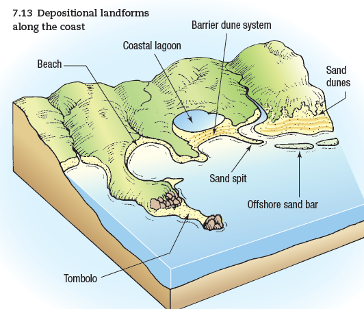
- Spit and Tombolo: Spits are narrow, elongated landforms that extend from the coast into the sea, formed by longshore drift and sediment deposition. A tombolo is a similar landform that connects an island to the mainland.
- Deltaic Islands (Chars): Bangladesh’s deltaic landscape features numerous deltaic islands, locally known as chars. These islands form and disappear due to the dynamic processes of sediment deposition and erosion in the deltaic region.
- River Mouth Bars: At the mouths of major rivers, sandbars and shoals often form, changing shape with the shifting river currents and tidal influence.
The coastal landforms in Bangladesh are constantly evolving due to the interaction between riverine and marine processes, making the region ecologically rich and geologically dynamic. The unique deltaic setting presents challenges and opportunities for sustainable coastal management and adaptation to changing environmental conditions, including sea-level rise and cyclonic events.
- Briefly discuss the origin of coastal and marine sediments. Do you think that the fall velocity and Flocculation of sediments in the coastal water of Bangladesh are Uniform? Justify (2020)
Coastal and marine sediments undergo various processes such as transportation, sorting, and deposition. The sediments accumulate on the seafloor, forming different types of marine deposits, including mud, sand, gravel, and organic-rich sediments. Over geological time, these sediments play a crucial role in the formation of sedimentary rock layers, shaping coastlines, and providing habitat for marine life. The study of coastal and marine sediments is essential for understanding Earth’s history, coastal dynamics, and marine ecosystems.Coastal and marine sediments originate from various sources and processes, and they play a significant role in shaping coastal environments and marine ecosystems. Here’s a brief overview of the
main origins of coastal and marine sediments:
- Weathering of Rocks: The primary source of sediments in coastal and marine environments is the weathering and erosion of rocks on land. Physical, chemical, and biological weathering processes break down rocks into smaller particles and minerals. These weathered materials are then transported by rivers, streams, and glaciers to the coast and eventually into the ocean.
- Riverine Inputs: Rivers are major contributors of sediment to coastal and marine environments. They transport a considerable amount of sediment from the land to the coast, especially during periods of heavy rainfall and flooding. The sediment carried by rivers includes a mix of fine particles (clay and silt) and coarser materials (sand and gravel).
- Erosion and Coastal Processes: Coastal erosion is a significant source of sediment in marine environments. Coastal cliffs, shorelines, and beach bluffs can erode due to wave action, storms, and other coastal processes, releasing sediment into the sea. The eroded material contributes to the formation of beaches, sandbars, and coastal landforms.
- Volcanic Activity: In regions with active volcanoes, volcanic eruptions can release volcanic ash and lava into the sea. Volcanic sediments, especially fine ash particles, can be carried by wind or water and deposited in coastal and marine areas.
- Biogenic Sources: Marine organisms, such as corals, mollusks, and foraminifera, contribute to the formation of sediments. Calcium carbonate and silica produced by these organisms accumulate on the seafloor, forming biogenic sediments like limestone and diatomaceous earth.
- Glacial Processes: Glaciers are a source of marine sediments, especially in areas with fjords and icebergs. Glaciers erode and transport rock fragments and sediments, depositing them in the ocean when icebergs break off or melt.
- Atmospheric Inputs: Dust and other airborne particles can be carried by wind and deposited into the ocean, contributing to marine sediments. These atmospheric inputs can come from various sources, including deserts, volcanic eruptions, and human activities.
No, the fall velocity and flocculation of sediments in the coastal waters of Bangladesh are not uniform. Several factors influence the fall velocity and flocculation of sediments in any coastal environment, and Bangladesh’s coastal waters are no exception. Here are some reasons why these processes are not uniform:
The fall velocity of sediments in the coastal waters of Bangladesh can vary depending on several factors, including sediment characteristics, water properties, and hydrodynamic conditions. As mentioned earlier, the fall velocity of sediments refers to the rate at which particles settle through the water column under the influence of gravity. Here are some factors that influence the fall velocity of sediments in the coastal waters of Bangladesh:
- Sediment Characteristics: The size, density, and shape of sediment particles are critical factors that affect their fall velocity. Coarser and denser particles tend to settle faster than finer and lighter particles. Sediments in coastal waters of Bangladesh can range from fine silt and clay to coarser sand and gravel.
- Hydrodynamic Conditions: Coastal waters experience dynamic hydrodynamic conditions, including tidal currents and wave actions. Stronger currents and wave turbulence can keep sediments in suspension longer, reducing their fall velocities. Conversely, calmer conditions allow sediments to settle more readily.
- Salinity and Temperature: Variations in salinity and temperature can influence water density and viscosity, which, in turn, affect sediment settling rates. Coastal waters of Bangladesh experience fluctuations in salinity and temperature due to seasonal changes and river discharges.
- Flocculation: Flocculation, the process by which small sediment particles come together to form larger aggregates or flocs, can impact sediment settling rates. The presence of organic matter and suspended sediment concentration can influence flocculation in coastal waters.
- Seasonal Variations: Seasonal changes, such as monsoon rainfall and river discharge, can introduce variations in sediment supply and characteristics, leading to changes in fall velocities during different times of the year.
- Anthropogenic Influences: Human activities, such as dredging, construction, and pollution, can introduce additional sediment into coastal waters or alter sediment characteristics, affecting fall velocities.
Due to the complex interactions of these factors, the fall velocity of sediments in the coastal waters of Bangladesh is likely to vary both spatially and temporally. Accurate measurements and modeling of sediment settling rates are crucial for understanding sediment transport, coastal erosion, and sedimentation processes in the region. Monitoring sediment dynamics is essential for coastal management and conservation efforts to ensure the sustainability of coastal ecosystems and mitigate the impact of natural and human-induced changes.
Flocculation of sediments in the coastal water of Bangladesh is a crucial process that influences sediment behavior, transportation, and settling rates. Flocculation refers to the process by which small individual particles in water come together to form larger aggregates or flocs. These flocs are composed of sediment particles bound together by various forces, including electrostatic, van der Waals, and hydrophobic interactions.Several factors contribute to flocculation in coastal waters of Bangladesh:
- Suspended Sediment Concentration: Higher concentrations of suspended sediment in the water column promote flocculation as more particles come into contact with each other, increasing the chances of aggregation.
- Salinity and Ionic Strength: Changes in salinity and ionic strength can affect the electrical charges of sediment particles, influencing their attraction or repulsion to each other and, consequently, promoting or inhibiting flocculation.
- Organic Matter Content: Organic matter, such as humic substances and biological debris, can act as binding agents that facilitate the formation of flocs by adsorbing onto sediment particles.
- Turbulence and Mixing: Turbulent conditions in coastal waters can promote the collision and adhesion of sediment particles, leading to flocculation.
- pH and Water Chemistry: Water pH and chemical composition can influence flocculation by altering the electrical charge on sediment particles.
Flocculation has several implications for coastal environments:
- Sediment Settling: Flocculation increases the size and mass of sediment particles, making them settle faster under the influence of gravity. This can lead to sediment deposition and the formation of mudflats and tidal flats in coastal areas.
- Water Clarity: Flocculation can improve water clarity by removing suspended sediment particles from the water column. Clearer water is essential for light penetration and the health of marine ecosystems.
- Nutrient and Contaminant Transport: Flocculation can influence the transport of nutrients and contaminants, as these substances can attach to sediment particles and be transported with the flocs.
- Coastal Erosion and Sediment Resuspension: Flocculation can also play a role in coastal erosion and sediment resuspension during high-energy events like storms, affecting the dynamics of sediment redistribution along the coast.
Understanding flocculation is crucial for managing coastal environments in Bangladesh and other coastal regions. It can help predict sediment dynamics, nutrient cycling, water quality, and the impact of human activities on coastal ecosystems. Monitoring flocculation processes and their response to changing environmental conditions can aid in implementing effective coastal management strategies for sustainable development and conservation.
The fall velocity and flocculation of sediments in Bangladeshi coastal waters, as in most coastal ecosystems, are highly changeable as a result of the intricate interactions of these elements. When researching sediment transport, coastal erosion, and sedimentation processes in these areas, it is essential to take this variety into account. For efficient coastal management and environmental conservation, it is crucial to collect precise data and comprehend the distinctive qualities of each coastal location. Coastal sediment dynamics are impacted by a combination of local and regional causes.
- Define drainage pattern and channel pattern. Discuss the characteristics of different types of channel pattern in humid environment. (With example from Bangladesh) (2013) (2014) (2017)
Drainage Pattern: A drainage pattern refers to the arrangement and distribution of rivers, streams, and other watercourses in a specific geographic area. It is a fundamental aspect of the landscape’s topography and is formed by the natural drainage network that carries water from higher elevations to lower elevations, eventually leading to the formation of river systems and watersheds.Drainage patterns are influenced by various geological, geomorphological, and climatic factors. They can be categorized into different types based on their overall appearance and characteristics, including:
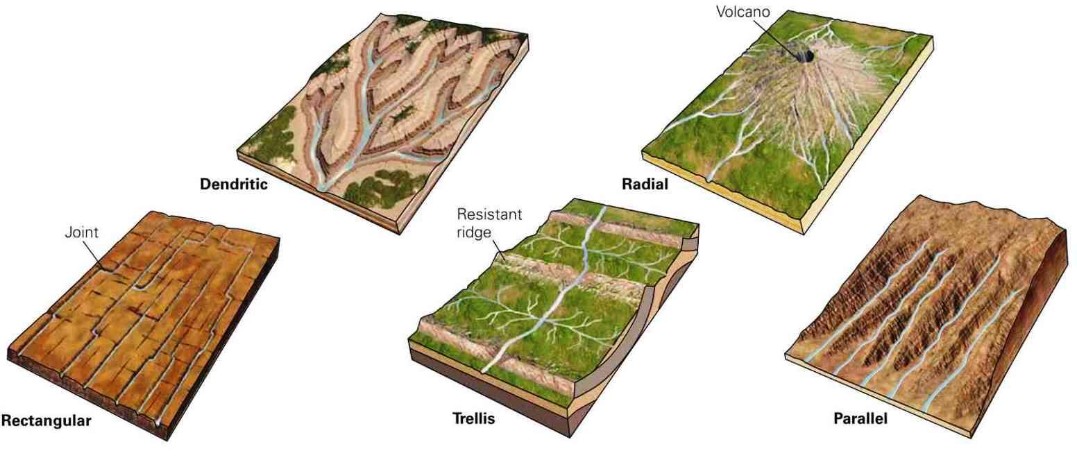
Types of drainage pattern
Dendritic patterns, which are by far the most common, also known as pinnate drainage, looks like the branching of a tree, found in regions with homogenous material. develop in areas where the rock (or unconsolidated material) beneath the stream has no particular fabric or structure and can be eroded equally easily in all directions. These develop in areas where the rock such as granite, gneiss, volcanic rock, and sedimentary rock which has not been folded (or unconsolidated material) beneath the stream has no particular fabric orstructure and can be eroded equally easily in all directions. Truly dendritic systems form in V-shaped valleys; as a result, the rock types must be impervious and non-porous.
Trellis drainage patterns typically develop where sedimentary rocks have been folded or tilted and then eroded to varying degrees depending on their strength. In this type, the short subsequent streams meet the main stream at right angles. Through soft rocks differential erosion paves the way for tributaries.
Rectangular patterns develop in areas that have very little topography and a system of bedding planes, fractures, or faults that form a rectangular network. These are found in regions that have undergone faulting. It develops in the area that have very little topography and a system of bedding planes, fractures, or faults that form a rectangular network.
Parallel drainage system is a pattern of rivers caused by steep slopes with some relief. Because of the steep slopes, the streams are swift and straight, with very few tributaries, and all flow in the same direction. Parallel drainage patterns form where there is a pronounced slope to the surface. A parallel pattern also develops in regions of parallel, elongate landforms like outcropping resistant rock bands.
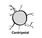
Radial drainage system, the streams radiate outwards from a central high point. Develops around a central elevated point where the streams radiate outwards from a central high point. Volcanoes usually display excellent radial drainage. Other geological features on which radial drainage commonly develops are domes and laccoliths. On these features the drainage may exhibit a combination of radial patterns. The tributaries from a summit follow the slope downwards and drain down in all directions.
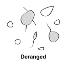
A deranged/ irregular drainage system is a drainage system in drainage basins where there is no coherent pattern to the rivers and lakes. It happens in areas where there has been much geological disruption. Develop from the disruption of a pre-existing drainage pattern.
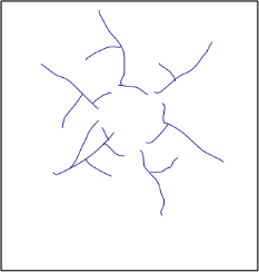
The centripetal drainage system is similar to the radial drainage system, with the only exception that radial drainage flows out versus centripetal drainage flows in.
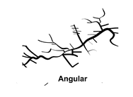
Angular drainage patterns form where bedrock joints and faults intersect at more acute angles than rectangular drainage patterns. Angles are both more and less than 90 degrees.
Annular Drainage Pattern- When the upland has an outer soft stratum, the radial streams develop subsequent tributaries which try to follow a circular drainage around the summit. It is best displayed by streams draining a maturely dissected structural dome or basin where erosion has exposed rimming sedimentary strata of greatly varying degrees of hardness.
Channel Pattern: A channel pattern refers to the plan-view configuration or shape of the river or stream channel, which is the path through which water flows. It is a key aspect of river morphology and is influenced by various factors, including the flow regime, sediment load, slope, and underlying geology.Channel patterns can be classified into different types based on their plan-view appearance. Original classifications of river channel pattern (Rossinskiy and Kuz’min, 1947; Leopold and Wolman 1957; Andreev and Yaroslavtsev, 1958) discerned three essential types: straight, meandering and braided. Anastomosing, split, wandering, ‘meandertal’ (meandering talweg) and some other patterns were distinguished later, and were interpreted either as transitional forms or as subtypes.
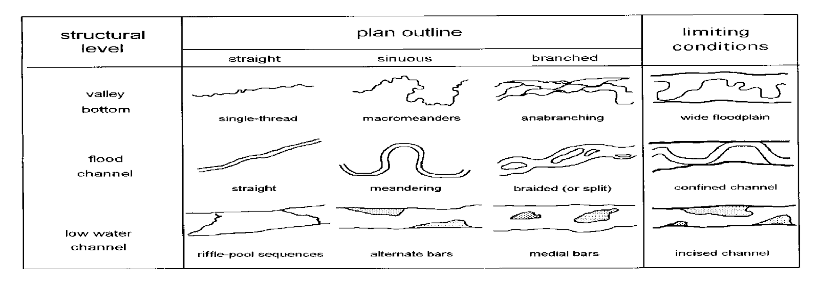
Most single-channel rivers and streams follow a winding path and straight channels are rare. Even where they do exist, variations are usually seen in flow patterns and bed elevation. Straight channels are relatively static, with rates of channel migration limited by a combination of low energy availability and high bank strength. This is especially true where the channel banks are formed from more resistant material, such as cohesive silts and clays.
2.Meandering channels
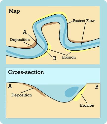
In large flood and delta plains, rivers rarely flow in straight courses. Loop-like channel patterns called meanders develop over flood and delta plains. In contrast to braided rivers, meandering rivers typically contain one channel that winds its way across the floodplain. As it flows, it deposits sediment on banks that lie on the insides of curves (point bar deposits), and erode the banks on the outside of curves. Streams generally erode on outer (cut) bank where velocity is greatest, and deposit on the inner sides of bends where velocity is less. Meanders tend to grow as the flow erodes the banks, favouring development of meandering channels. Normally, in meanders of large rivers, there is active deposition along the convex bank and undercutting along the concave bank.
3.Braided channels
Braided channels have substantial inputs of bed flow from upstream catchments. When sediment supply exceeds the transport energy in a stream, it is unable to move all the available load and tends to deposit the coarsest sediment, causing one or more central bars to form, which divert the flow towards the banks. This flow in turn increases lateral erosion on the banks, causing more deposition and bar formation. Braided channels tend to form in streams with a highly variable discharge, easily erodible banks, and/or a high sediment load and they are characterized by numerous channels that split off and rejoin each other to give a braided appearance.
Braided rivers are usually wide and relatively shallow (they have a high channel width to depth ratio). As the valley widens, the water column is reduced and more and more sediment get deposited as islands and lateral bars, resulting in the development of separate channels of flow.
4.Anastomosing Channel: An anastomosing channel pattern is characterized by a series of interconnected, stable channels that divide and rejoin, similar to a braided pattern. It is typically found in areas with abundant vegetation and fine-grained sediment.
In a humid environment, such as Bangladesh with its extensive river systems and abundant rainfall, various types of channel patterns can be observed. These channel patterns are influenced by factors such as the type of sediment, flow regime, and topography of the region. Here are the characteristics of different types of channel patterns commonly found in humid environments, along with examples from Bangladesh:
1. Meandering Channel Pattern: Characteristics:
- Meandering channels have a sinuous, winding path with a series of alternating curves called meanders.
- They often occur in low-gradient areas with fine-grained sediment, where water flow is relatively slow and sediment load is moderate.
- The outer banks of meandering channels experience erosion, while sediment is deposited on the inner banks, leading to the continuous shifting of the channel over time.
Example from Bangladesh:
The Jamuna River, a major distributary of the Brahmaputra, exhibits a meandering channel pattern in its lower reaches, particularly in the Sirajganj and Bogura districts.
2. Braided Channel Pattern: Characteristics:
- Braided channels consist of multiple interconnected and shifting channels that split and rejoin, creating a complex network.
- They are common in areas with high sediment load, steep slopes, and variable flow conditions.
- The channels form shallow, braided islands and bars composed of coarse sediment in between the flowing water.
Example from Bangladesh:
The lower reaches of the Padma River (the main distributary of the Ganges) and the Jamuna River often exhibit a braided channel pattern during the monsoon season when the rivers carry a massive amount of sediment.
3. Anastomosing Channel Pattern: Characteristics:
- Anastomosing channels consist of a series of interconnected, stable channels that divide and rejoin.
- They are commonly found in low-gradient areas with abundant vegetation and fine-grained sediment.
- The channels are separated by stable islands and support diverse and stable aquatic habitats.
Example from Bangladesh:
Some distributaries of the Brahmaputra, like the Old Brahmaputra or the Kumar River, display an anastomosing channel pattern, forming a network of interconnected channels in the deltaic region.
4. Straight Channel Pattern: Characteristics:
- Straight channels have a linear, straight course without significant meandering or bending.
- They typically occur in high-gradient areas with fast-flowing water and coarse sediment.
- These channels often exhibit higher energy and are associated with erosion and sediment transport.
Example from Bangladesh:
In the hilly regions of southeastern Bangladesh, rivers like the Sangu and Matamuhuri display straight channel patterns due to the steep topography.
The diverse range of channel patterns in the humid environment of Bangladesh reflects the complex interactions between rivers, sediment supply, topography, and hydrological conditions. These patterns are continually evolving due to natural processes and human activities. Understanding these channel patterns is essential for sustainable river management, flood control, and conserving the unique ecosystems of Bangladesh’s riverine landscape.
- Which type(s) of drainage pattern has been developed in the Ganges-Brahmaputra-Meghna. (2020)
The Ganges-Brahmaputra-Meghna (GBM) river system, also known as the Bengal Delta or the Ganges Delta, is one of the most extensive and significant river systems in the world. It is located in South Asia and covers parts of India, Bangladesh, and Myanmar. The GBM river system is formed by three major rivers: the Ganges, the Brahmaputra, and the Meghna, along with their numerous tributaries and distributaries.Key Features of the Ganges-Brahmaputra-Meghna (GBM) River System:
- Geographical Extent: The GBM river system covers an area of about 105,000 square kilometers (approximately 40,540 square miles), making it the world’s largest delta. It stretches from the confluence of the Ganges and Brahmaputra rivers in Bangladesh to the Bay of Bengal.
- River Sources: The Ganges River, originating in the Himalayas, flows through northern India and then enters Bangladesh. The Brahmaputra River, known as the Jamuna in Bangladesh, originates in Tibet, flows through India’s northeastern states, and enters Bangladesh from the northwest. The Meghna River originates in India’s northeastern state of Meghalaya and flows through Bangladesh, eventually joining the combined flow of the Ganges and Brahmaputra rivers.
- River Dynamics: The GBM river system is highly dynamic, with significant seasonal fluctuations in water flow due to the monsoon rains and snowmelt in the Himalayas. During the monsoon season (June to October), the rivers receive heavy rainfall, leading to massive inflows and flooding in the deltaic region.
- Distributaries and Delta Formation: The deltaic region of the GBM river system is characterized by a vast network of distributaries, tidal creeks, and estuaries. The distributaries carry water and sediment from the main rivers towards the Bay of Bengal, creating an intricate and ever-changing deltaic landscape.
- Ecological Significance: The GBM delta is a highly productive and ecologically diverse region, providing critical habitats for various flora and fauna, including the iconic Bengal tiger and the endangered Ganges River dolphin. The delta supports extensive mangrove forests, including the Sundarbans, the largest mangrove forest in the world.
- Human Population: The Ganges-Brahmaputra-Meghna delta is one of the most densely populated regions on Earth, with millions of people relying on the delta’s resources for their livelihoods. The delta is a vital agricultural region, producing rice, jute, and other crops.
- Climate Change Vulnerability: The GBM delta is highly vulnerable to the impacts of climate change, particularly sea-level rise and increased frequency of extreme weather events. Rising sea levels and changing hydrological patterns pose significant challenges for the delta’s population and ecosystems.
The Ganges-Brahmaputra-Meghna (GBM) river system is not only of immense geographical and ecological importance but also plays a vital role in the socio-economic development of the countries it traverses. However, the deltaic region faces numerous challenges, including water management, flood control, and environmental conservation, as it adapts to the ongoing changes brought about by natural and human-induced factors.The primary drainage patterns observed in the Ganges-Brahmaputra-Meghna delta are:
- Dendritic Pattern: The majority of the Ganges-Brahmaputra-Meghna delta displays a dendritic drainage pattern. In this pattern, the river channels and tributaries resemble the branching pattern of a tree, with numerous smaller streams converging into larger rivers like the Ganges, Brahmaputra, and Meghna. The dendritic pattern is common in regions with uniform geological formations and gentle slopes, which are characteristic of the deltaic plains.
- Estuarine Pattern: The deltaic region is characterized by extensive estuarine environments where rivers meet the Bay of Bengal. Estuarine patterns involve a mix of river channels, tidal creeks, and distributaries interacting with tidal movements and saltwater intrusion. The Ganges-Brahmaputra-Meghna estuarine system is one of the most complex and dynamic estuarine systems globally.
- Tidal Creeks and Channels: The tidal influence in the deltaic region has led to the development of numerous tidal creeks and channels. These tidal channels play a significant role in transporting sediments, exchanging freshwater and saltwater, and providing habitat for diverse marine and estuarine species.
- Distributary Pattern: The Ganges-Brahmaputra-Meghna delta is characterized by a vast network of distributaries, which are river channels that branch off from the main rivers and carry water and sediment towards the sea. The distributaries in this delta are subject to frequent shifts and avulsions due to sediment deposition and erosion.
Overall, the Ganges-Brahmaputra-Meghna delta showcases a mix of dendritic, estuarine, and distributary drainage patterns, creating a dynamic and ever-changing network of river channels, tidal creeks, and estuarine environments. The complex interplay between river processes, tidal influences, sediment dynamics, and sea-level rise makes the deltaic region of Bangladesh a fascinating and challenging area to study in terms of drainage patterns and geomorphological evolution.
- Discuss the importance of morphometric analysis of drainage system for flood management and agricultural planning. (2015) (2018) (2021)
Morphometric analysis of drainage systems is a quantitative study of various geometric parameters and characteristics related to river networks, watersheds, and their associated landforms. This analysis plays a crucial role in understanding the hydrological behavior, erosion potential, and landscape evolution of a drainage basin. It is conducted using topographic maps, satellite imagery, Geographic Information Systems (GIS), and other remote sensing techniques. Here are some key aspects of morphometric analysis of drainage systems:
- Stream Order: Stream order is a hierarchical classification of streams within a drainage basin. The main river channel is assigned the first order, and each subsequent tributary adds one to the order. Higher-order streams generally have larger drainage areas and carry more water.
- Stream Length and Stream Density: Stream length is the total length of all streams within a basin, while stream density is the total length of streams per unit area. High stream density indicates a well-developed drainage system.
- Bifurcation Ratio: The bifurcation ratio is the ratio of the number of stream segments of one order to the number of stream segments of the next lower order. It provides insights into the branching pattern and complexity of the drainage network.
- Drainage Density: Drainage density is the total length of all streams divided by the basin area. High drainage density indicates a dense and well-connected stream network, which can influence the basin’s response to rainfall and potential for flooding.
- Stream Frequency: Stream frequency is the number of streams per unit area. It helps in understanding the density and distribution of streams within the basin.
- Elongation Ratio: The elongation ratio is the ratio of the longest dimension of the basin to its perpendicular width. It provides information about the basin’s shape and can indicate its susceptibility to flood and erosion.
- Basin Shape Index: The basin shape index compares the actual basin area to the basin’s theoretical circular area with the same perimeter. It provides insights into the basin’s shape complexity.
- Relief Parameters: Morphometric analysis includes the measurement of relief parameters, such as slope, aspect, and elevation. These parameters help in understanding the topography and terrain features of a region, which are crucial for various applications, including land use planning, engineering, and hazard assessment.
- Hypsometric Analysis: Hypsometric analysis involves the study of elevation distribution in a basin. The hypsometric curve shows the percentage of land area at different elevations, providing insights into the stage of landscape development and erosion history.
- Drainage Morphometry: It involves the quantitative study of river basins and their drainage networks. Parameters like stream length, stream density, stream order, and basin characteristics are analyzed to understand the hydrological behavior and erosion potential of the drainage system.
- Watershed Analysis: Morphometric analysis of watersheds helps in assessing their hydrological characteristics, such as water yield, runoff potential, and groundwater recharge. It aids in identifying critical areas for water resource management and sustainable land use planning.
- Shape Analysis: Morphometric analysis also deals with the shape characteristics of landforms, including river profiles, valley cross-sections, and drainage patterns. Shape analysis helps in identifying landform evolution processes, tectonic activities, and erosion patterns.
- Remote Sensing Applications: Remote sensing data, such as satellite imagery and LiDAR data, are often utilized in morphometric analysis to obtain accurate and extensive information about the Earth’s surface. Remote sensing techniques facilitate the extraction of morphometric parameters over large areas and support the study of landform changes over time.
Importance: Morphometric analysis is essential for understanding the geomorphological processes, hydrological behavior, and landscape evolution of a region. It has numerous applications in various fields, including:
- Watershed management and water resource planning.
- Flood modeling and floodplain management.
- Soil erosion assessment and conservation planning.
- Geohazard identification and mitigation.
- Landscape evolution studies and tectonic analysis.
- Environmental impact assessment for development projects.
Morphometric analysis of drainage systems is widely used in various fields, including hydrology, geomorphology, environmental management, and engineering. It helps in flood risk assessment, water resource planning, erosion control, land use planning, and environmental impact assessment. By understanding the spatial characteristics of drainage systems, researchers, planners, and policymakers can make informed decisions and implement effective strategies for sustainable land and water management.
Morphometric analysis of drainage systems is of significant importance for flood management due to the following reasons:
- Identification of Flood-Prone Areas: By analyzing the morphometric parameters of the drainage basin, such as drainage density, elongation ratio, and stream frequency, areas that are more susceptible to flooding can be identified. High drainage density and low elongation ratios, for example, indicate a higher potential for overland flow and increased flood risk.
- Understanding Basin Response: Morphometric analysis provides insights into the basin’s response to precipitation events. By examining parameters like stream order and basin slope, it becomes possible to understand how quickly water will move through the drainage system and reach the main rivers during heavy rainfall, which is crucial for flood forecasting.
- Design of Flood Control Measures: Knowledge of morphometric characteristics helps in designing effective flood control measures. For instance, information about the basin’s shape, size, and gradient is essential for designing and locating reservoirs, detention basins, and flood control structures to manage the flow of water during floods.
- Sediment Transport and Erosion Control: Morphometric analysis also sheds light on the potential for sediment transport and erosion within the drainage system. Understanding these processes is crucial for designing erosion control measures and managing sedimentation in rivers and reservoirs to prevent siltation and reduce flood risks.
- Prioritization of Flood Mitigation Efforts: By conducting morphometric analysis for multiple drainage basins, authorities can prioritize flood mitigation efforts based on the level of flood risk in different areas. This information helps allocate resources more efficiently and effectively.
- Flood Hazard Zonation: Morphometric analysis aids in flood hazard zonation, where areas are classified based on their flood risk levels. This zonation guides land use planning and helps avoid development in high-risk flood-prone areas.
- Climate Change Impact Assessment: Morphometric analysis can also be used to assess the potential impact of climate change on flood patterns. Changes in precipitation patterns and increased frequency of extreme events can be evaluated in the context of the basin’s characteristics.
- Floodplain Mapping: Morphometric analysis supports the mapping of floodplains, which are crucial for understanding the extent of potential flooding during different flood scenarios. Floodplain maps assist in emergency response planning and evacuation strategies.
Overall, morphometric analysis of drainage systems is a valuable tool for flood management, allowing for a better understanding of flood risks, improved flood control measures, and more informed decision-making to reduce the impact of flooding on communities, infrastructure, and the environment. It is an integral part of comprehensive flood risk assessment and management strategies.
Morphometric analysis of drainage systems is of significant importance for agriculture planning due to the following reasons:
- Water Resource Assessment: Morphometric analysis provides valuable information about the hydrological characteristics of the drainage basin, including water availability, groundwater recharge potential, and streamflow patterns. This information is crucial for determining water availability for agricultural purposes and planning irrigation systems.
- Land Suitability Mapping: By understanding the morphometric parameters of the drainage system, areas suitable for agriculture can be identified. Factors like slope, aspect, and elevation help in determining the best locations for different types of crops and land use practices.
- Soil Erosion Control: Morphometric analysis helps in assessing the potential for soil erosion within the drainage basin. Understanding the areas prone to erosion allows for targeted soil conservation measures, such as contour plowing, terracing, and vegetation management, to protect agricultural lands from erosion.
- Drainage Planning: The analysis of drainage patterns and relief parameters helps in planning efficient drainage systems for agricultural fields. Proper drainage is essential for managing excess water during periods of heavy rainfall and preventing waterlogging, which can adversely affect crop growth.
- Flood Risk Assessment: Morphometric analysis assists in assessing the flood risk in agricultural areas. By identifying flood-prone regions and understanding the basin’s response to heavy rainfall, farmers can implement flood control measures, such as constructing embankments and flood diversion channels, to protect crops from inundation.
- Watershed Prioritization: Morphometric analysis allows for the prioritization of watersheds based on their agricultural potential and resource availability. This prioritization helps in targeting agricultural development efforts and resource allocation to maximize productivity.
- Cropping Pattern and Agroforestry Planning: Understanding the shape and size of the drainage basin aids in planning appropriate cropping patterns and agroforestry practices. Farmers can choose crops and tree species that are well-suited to the local topography and hydrological conditions.
- Climate Change Adaptation: Morphometric analysis can also be used to assess the impact of climate change on agriculture. Changes in precipitation patterns and temperature can influence water availability and agricultural productivity, and this information can guide farmers in adapting their practices to the changing climate.
- Optimal Land Use Planning: By considering the morphometric characteristics of the drainage basin, agricultural planners can make informed decisions about the most suitable land use practices for different areas. This ensures optimal land use, increased agricultural productivity, and sustainable resource management.
Overall, morphometric analysis of drainage systems is an essential tool for agriculture planning, enabling the efficient and sustainable use of water resources, soil conservation, flood mitigation, and the development of agriculture practices that are well-adapted to the local landscape and climatic conditions. It helps farmers make informed decisions and contributes to the overall success and resilience of agricultural systems.
- Define flood and floodplain. Discuss the morphological and ecological characteristics of floodplains with particular attention to floodplain management in Bangladesh. (2014) (2017) (2019)
Flood: A flood is an overflow of water onto normally dry land, typically caused by heavy rainfall, snowmelt, dam failure, or tidal surge. Floods are natural disasters that can lead to extensive damage to property, infrastructure, and the environment. They can occur in various forms, including riverine floods (caused by overflowing rivers), flash floods (rapid and intense floods in small streams or urban areas), coastal floods (due to storm surges or tsunamis), and inland floods (resulting from prolonged heavy rainfall).
Floods can have severe impacts on human lives, communities, and ecosystems. They can disrupt transportation, damage buildings and infrastructure, cause soil erosion, contaminate water sources, and displace people from their homes. Floods also play an essential role in natural processes, such as replenishing groundwater, maintaining wetlands, and redistributing sediment.
Floodplain: A floodplain is a flat or gently sloping area adjacent to a river, stream, or other water body that is susceptible to flooding during high water events. It forms a natural extension of the river channel and serves as a temporary storage area for floodwaters during periods of excessive flow. Floodplains are created through the gradual deposition of sediments by the river over time.
Floodplains are essential components of river ecosystems and provide numerous benefits. They act as natural buffers against flooding, absorbing excess water and reducing flood intensity downstream. Floodplains also support rich biodiversity and provide fertile soil for agriculture due to the deposition of nutrient-rich sediments. However, the location and development of human settlements in floodplain areas can increase the risk of flood damage and pose challenges for flood management and disaster preparedness.
In urban areas, floodplains are often prone to development, which can exacerbate the impact of floods by reducing the area available for floodwaters to spread. Proper management and planning are crucial for balancing the natural functions of floodplains with the need for sustainable development and flood risk reduction.
Morphological Characteristics of Floodplains:
- Flat Topography: Floodplains are characterized by low-lying and flat topography, making them susceptible to inundation during periods of high-water flow in rivers and monsoon rains. The gradual slope allows floodwaters to spread over large areas.
- Alluvial Soil Deposits: Floodplains are formed by the deposition of alluvial sediments carried by rivers during floods. These sediments, rich in nutrients, contribute to the fertility of floodplain soils, making them suitable for agriculture.
- Braided Channel Patterns: In active floodplain regions, the river channels often exhibit a braided pattern with numerous interconnected channels and shifting sandbars due to frequent changes in water flow and sediment transport.
- Natural Levees: Over time, rivers deposit sediments along their banks during floods, creating natural levees. These elevated banks help confine floodwaters to the channel, reducing the extent of flooding on the floodplain.
- Backswamps and Oxbow Lakes: During flood events, some areas of the floodplain may become temporarily inundated, forming backswamps and oxbow lakes. These areas play a crucial role in water storage and maintaining ecosystem health.
Ecological Characteristics of Floodplains:
- Biodiversity Hotspots: Floodplains are rich in biodiversity and serve as important habitats for various plant and animal species. They support a wide range of terrestrial and aquatic life, including fish, amphibians, birds, and waterfowl.
- Nursery for Fish: Floodplains provide essential nursery habitats for many fish species. During floods, juvenile fish find refuge in shallow, vegetated areas where they can feed and grow.
- Nutrient Cycling: Floodplains play a vital role in nutrient cycling, as the periodic flooding deposits nutrient-rich sediments, enhancing soil fertility and supporting lush vegetation growth.
- Water Filtration and Purification: Floodplains act as natural filters, purifying water by trapping sediment and absorbing nutrients and pollutants. This helps maintain water quality in the rivers and supports clean drinking water sources.
- Floodplain Forests and Wetlands: Floodplains are often covered by forests and wetlands, which provide valuable ecosystem services, including carbon sequestration, flood mitigation, and wildlife habitat.
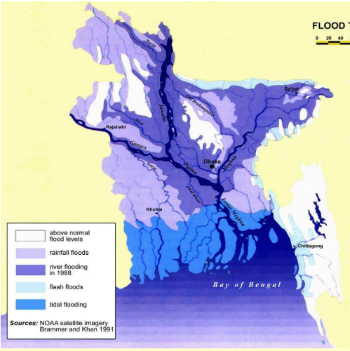
TYPES OF FLOODS IN BANGLADESH
The term flood is generally used when the flows in the rivers and channel cannot be contained within natural orartificial river banks. By spilling the river banks, when water inundates flood plains and adjoining high lands to someextent or when the water level in the river or channels exceeds certain stage, the situation then termed as flood(Hossain, 2004). In Bangladesh, the following types of floods are normally encountered. Area affected by differenttypes of flooding is presented in Fig.
- Flash Flood from Hilly Areas: Flash flood prone areas of the Bangladesh are at the foothills. Intense local and short-lived rainfall often associated with mesoscale convective clusters is the primary cause of flash floods. These are characterized by a sharp rise followed by a relatively rapid recession. Often with high velocities of on-rush flood damages crops, properties and fish stocks of the wetland. Flash flood can occur within a few hours. In the months of April and May flash floods affect the winter rice crop at the harvesting stage, and are common in the districts of Northeast and Southeast regions of the country.
- Monsoon Floods or Normal Flood from Major Rivers: The word flood is generally synonymous with river flood. River flood is a common phenomenon in the country caused by bank overflow. Of the total flow, around 80% occurs in the 5 months of monsoon from June to October (WARPO, 2004). A similar pattern is observed in case of rainfall also. As a consequence to these skewed temporal distribution of river flow and rainfall, Bangladesh suffers from abundance of water in monsoon, frequently resulting into floods and water scarcity in other parts of the year, developing drought conditions (IEB, 1998). Climatologically, the discharge into Bangladesh, from upper catchments, occurs at different time of the monsoon. In the Brahmaputra maximum discharge occurs in early monsoon in June and July whereas in the Ganga maximum discharge occurs in August and September. Synchronisation of the peaks of these rivers results in devastating floods. Such incidents are not uncommon in Bangladesh. The rivers of Bangladesh drain about 1.72 million sq km area of which 93% lies outside its territory in India, Nepal, Bhutan and China. The annual average runoff of the cross-boundary rivers is around 1200 cubic kilometres (WARPO, 2004).
- Rain-fed Flood: This kind of flood generally occurs in many parts of the country but is mainly prevalent in the south-western part of the country. This kind of flood also occurs in the flood plains where natural drainage systems have been disturbed either due to human interferences e.g. construction of unplanned rural roads and encroachment of river courses etc. or due to gradual decay of the natural drainage system. When intense rainfall takes place in those areas, the natural drainage system cannot carry the run-off generated by the storm and causes temporary inundation in many localities. This kind of rain-fed flood is increasing in the urban areas.
- Floods Due To Storm Surges: This kind of flood mostly occurs along the coastal areas of Bangladesh over a coastline of about 800 km along the southern part. Continental shelves in this part of the Bay of Bengal are shallow and extend to about 20-50 km. Moreover, the coastline in the eastern portion is conical and funnel like in shape. Because of these two factors, storm surges generated due to any cyclonic storm is comparatively high compared to the same kind of storm in several other parts of the world. In case of super-cyclones maximum height of the surges were found to be 10-15 m, which causes flooding in the entire coastal belt. The worst kind of such flooding was on 12 Nov 1970 and 29 April 1991 which caused loss of 300,000 and 138,000 human lives respectively (FFWC, 2005). Coastal areas are also subjected to tidal flooding during the months from June to September when the sea is in spate due to the southwest monsoon wind.
Floodplain Management in Bangladesh:
Event: Impact
1974 flood: Inundated 36% of the country (FFWC, 2005), estimated damages US$ 57.9 Million, over 28,700 deaths
1987 flood: Inundated over 57,000 sq-km area, estimated damage US$ 1.0 billion and human death 2055 (The World Bank, 2002)
1988 flood: Inundated 61% of the country, persons affected 45 million, 2300 deaths, damage worth about US$ 1.2 billion (The World Bank, 2002)
1998 flood: Inundated 100,250 sq-km (68%) of the country, 1100 deaths, persons affected 31 million, damaged 500,000 homes, 23,500 km roads and 4500 km embankment, destroyed crops of 500,000 ha of land, damage worth about US$ 2.8 billion (The World Bank, 2002)
2004 flood: Inundated 38% of the country, 750 deaths, persons affected 36 million, damaged 58,000 km roads and 3,100 km embankment, crop damage 1.3 million ha, damage worth about US$ 2.2 billion (ADB-World Bank, 2004)
- Bangladesh, a low-lying deltaic country, is highly susceptible to flooding due to its extensive network of rivers and monsoon rains. Floodplain management in Bangladesh is a critical aspect of disaster preparedness and sustainable development. Some key strategies and practices include:
- Flood Forecasting and Early Warning Systems: Implementing modern flood forecasting and early warning systems helps to alert communities about potential floods, enabling them to take preventive measures and evacuate to safer areas.
- Flood Control and Drainage Infrastructure: Constructing embankments, levees, and drainage channels helps control floodwaters and protect densely populated areas and agricultural land from inundation.
- Flood-Resilient Agriculture: Promoting flood-resilient agricultural practices, such as floating gardens (Baira), flood-tolerant crop varieties, and water management techniques, helps farmers adapt to seasonal flooding.
- Floodplain Zoning: Identifying and zoning floodplain areas based on flood risk and land use suitability helps regulate development and minimize damage from floods.
- Integrated Water Resource Management: Adopting an integrated approach to water resource management, considering the needs of both humans and the environment, helps ensure sustainable use of water in the floodplain.
- Reforestation and Wetland Conservation: Preserving and restoring floodplain forests and wetlands enhances their ecological functions, such as flood mitigation, biodiversity conservation, and water purification.
- Community-Based Flood Management: Involving local communities in flood management and disaster response planning fosters a sense of ownership and empowers them to take proactive measures during flood events.
In Bangladesh, floodplain management is a dynamic process that requires continuous monitoring, adaptive strategies, and collaboration among various stakeholders, including government agencies, NGOs, and local communities. The aim is to strike a balance between harnessing the benefits of the fertile floodplains for agriculture and conserving their ecological integrity while mitigating the impacts of floods on human lives and livelihoods.
- What is glacier?What are the dominant processes present in glacial geomorphic environment? Briefly describe the erosional and depositional features in glacial geomorphic environment. (2020)

A glacier is a large mass of ice that forms over many years as snow accumulates, compacts, and recrystallizes under its weight. Glaciers are one of the most prominent features of Earth’s cryosphere, which includes all the frozen parts of the planet, such as ice caps, ice sheets, and frozen ground.
Glaciers can be found on every continent except Australia, and they play a crucial role in shaping the Earth’s landscape and influencing global climate. They act as reservoirs of freshwater, affecting sea levels and providing a source of water for rivers and ecosystems.
Formation: Glaciers form in regions where the rate of snow accumulation exceeds the rate of snowmelt and sublimation (the process where ice directly changes into water vapor without melting). Over time, the accumulated snow compresses into ice.
In glacial geomorphic environments, several dominant processes shape the landscape and create distinctive landforms. Glacial geomorphology is the study of these landforms and the processes associated with glaciers. The primary processes present in glacial geomorphic environments include:
- Glacial Erosion: Glacial erosion is a significant process in which glaciers carve and sculpt the landscape by removing rock and sediment from the valley floors and walls. Glaciers act as powerful bulldozers, plucking and scraping the bedrock and transporting the eroded material.
- Abrasion: As glaciers move, they carry rock fragments and sediments embedded in their ice. These materials act as abrasives, wearing away the underlying bedrock through friction, resulting in glacial striations and polishing of rock surfaces.
- Plucking: Plucking is a process where glaciers freeze onto loose bedrock or sediment, and as they move, they lift and detach these materials. The plucked debris is then incorporated into the glacier’s ice, which contributes to glacial erosion.
- Transportation: Glaciers transport eroded materials, including boulders, gravel, sand, and silt, as they flow downhill. The transported materials are known as glacial till or drift, which gets deposited as the glacier retreats or melts.
- Glacial Deposition: When the glacier’s capacity to transport sediments decreases (often due to melting), it deposits the materials it was carrying. Glacial deposition results in various landforms, such as moraines, drumlins, and eskers.
- Moraine Formation: Moraines are accumulations of glacial till that get deposited along the edges and at the terminus of glaciers. They can be lateral moraines (along the sides of glaciers), medial moraines (where two glaciers merge), or terminal moraines (at the glacier’s furthest extent).
- Drumlins: Drumlins are elongated, smoothly shaped hills composed of glacial till. They form underneath the glacier and indicate the direction of ice flow during glaciation.
- Eskers: Eskers are long, winding ridges composed of sand and gravel that were deposited by meltwater flowing through tunnels within or beneath glaciers. They form when sediment-filled subglacial channels melt and leave behind their deposits.
- Outwash Plains: When glaciers melt, they release vast amounts of meltwater that carries sediments away from the ice. The sediments get sorted and deposited in outwash plains, creating layers of sorted material such as sands and gravels.
- Glacial Lakes: Glacial lakes form when meltwater accumulates in depressions left by retreating glaciers. These lakes often have distinctive colors due to the presence of suspended glacial flour (finely ground rock particles).
Overall, glacial geomorphic environments are shaped by the interplay of erosion, transportation, and deposition processes associated with glaciers. The resulting landforms are unique and provide valuable insights into past glaciations and the dynamics of Earth’s climate and landscapes.
Erosional Features in Glacial Geomorphic Environment:
- U-shaped Valleys: Glaciers erode existing river valleys, transforming them into U-shaped valleys with steep, straight sides and flat bottoms. The glacier’s erosive power removes the valley’s softer materials, leaving behind a broad and deep trough.
- Cirques: Cirques are amphitheater-like depressions formed at the head of glacial valleys. They result from intense glacial erosion, where the ice carves into the mountain slopes, creating a bowl-shaped hollow.
- Arêtes: Arêtes are narrow, sharp ridges that form between two cirques. Glacial erosion on both sides of the ridge carves away the rock, leaving a sharp, knife-edge feature.
- Horns: Horns are pointed peaks that result from the erosion of multiple cirques on the sides of a single mountain. The ice carves away the rock from all sides, creating a distinct peak with steep slopes.
- Glacial Striations and Polished Surfaces: Glaciers leave striations, or grooves, on bedrock surfaces due to the abrasion caused by rock fragments embedded in the ice. Polished surfaces are also common, where the glacier smoothes and polishes the bedrock.
Depositional Features in Glacial Geomorphic Environment:
- Moraines: Moraines are accumulations of glacial till (unsorted sediments) that get deposited by glaciers. Terminal moraines form at the glacier’s furthest extent, lateral moraines occur along the sides of glaciers, and medial moraines form where two glaciers merge.
- Drumlins: Drumlins are elongated, teardrop-shaped hills composed of glacial till. They form underneath the glacier and indicate the direction of ice flow during glaciation.
- Erratics: Erratics are large boulders that are transported and deposited by glaciers far from their source regions. These boulders differ in lithology from the local bedrock and provide evidence of past glaciations.
- Outwash Plains: When glaciers melt, they release large volumes of meltwater carrying sediments away from the ice. The sediment gets sorted and deposited in outwash plains, creating layers of sorted material such as sands and gravels.
- Kettle Holes: Kettle holes are depressions in the ground formed when blocks of ice become buried in glacial deposits. When the ice eventually melts, it leaves behind a depression that may fill with water, creating a kettle lake.
- Eskers: Eskers are long, winding ridges composed of sand and gravel that were deposited by meltwater flowing through tunnels within or beneath glaciers. They form when sediment-filled subglacial channels melt and leave behind their deposits.
Glacial erosional and depositional features provide valuable clues for reconstructing past glaciations, understanding the dynamics of ice flow, and studying Earth’s climatic history. These distinctive landforms are found in regions that were once covered by glaciers and are essential for deciphering the geological history of glaciated landscapes.
- Define and classify Delta. Discuss the evolution process and morphological characteristics of a delta with reference to the GBM delta system. (2017)
Delta: A delta is a landform that forms at the mouth of a river, where it meets a body of standing water, such as a lake, sea, or ocean. Deltas are characterized by their triangular or fan-shaped appearance and are formed through the accumulation of sediments carried by the river as it enters the still water of the larger body.Deltas are dynamic environments influenced by ongoing sediment deposition, erosion, and changing water levels. They are important ecosystems that provide valuable habitats for various flora and fauna. Due to their unique characteristics and sensitivity to human activities, deltas require careful management and conservation efforts to preserve their ecological integrity and reduce the impact of human-induced changes on these valuable landforms.In a strict definition,Randel Tom Cox writes, “a ‘delta’ is a pile of gravel, sand, and mud that is being dumped at a continent’s edge at the mouth of a major river.
Classification of Deltas: Deltas can be classified based on various factors, including the dominant processes of sediment deposition, the shape of the delta, and the main factors influencing their formation. The primary classification of deltas is as follows:
Based on Dominant Depositional Process:
- River-Dominated Deltas: These deltas are mainly influenced by the river’s sediment discharge and its dominance in shaping the deltaic landforms. Examples include the Mississippi River Delta and the Nile Delta.
- Wave-Dominated Deltas: In these deltas, wave action from the body of standing water plays a significant role in shaping the deltaic landforms. Examples include the Ganges-Brahmaputra Delta and the Amazon Delta.
- Tide-Dominated Deltas: Tidal currents are the primary driving force in shaping these deltas. Tidal energy plays a crucial role in the sediment deposition and formation of landforms. Examples include the Sundarbans Delta and the Mahanadi Delta.
Based on Delta Shape:
- Arcuate Delta: Arcuate deltas have a curved or semi-circular shape, often resembling the letter ‘C.’ They are common in areas with moderate wave and tidal influences.
- Bird’s-foot Delta: These deltas have several distributaries that extend out into the body of water, resembling the toes of a bird’s foot. They often form in areas with strong river currents and low wave and tidal energy. The Mississippi delta exhibits the best example of bird-foot delta.
- Cuspate Delta: Cuspate deltas have triangular or pointed shapes with projecting lobes. They are formed where opposing currents and sediment supply create a sharp point.
- Estuarine Delta: An estuarine delta forms where a river meets a narrow, funnel-shaped estuary with strong tidal currents and limited wave energy.The significance examples of estuarine delta are Mackenzia delta, Vistuala delta, Elb delta, Ob delta, Seine delta, Hudson Delta etc.
Based on Dominant Factors Influencing Formation:
- Fluvial Deltas: Formed mainly by river processes, these deltas have significant contributions from sediment-laden rivers.
- Tidal Deltas: Formed primarily by tidal processes, these deltas occur in regions with strong tidal currents and minimal riverine influence.
- Wave Deltas: Formed predominantly by wave action, these deltas are typical in regions with strong wave energy and limited river discharge.
Morphology of deltas
Much sediment is deposited where rivers empty into lakes, or into the ocean. This is because the velocity of the stream current comes to a stop there, and as the flow slows down, the sediments being transported by the stream settle to the bottom and are deposited. Deltas along ocean coasts are transitional environments, where the surface of the earth gradually slopes from on land to beneath the ocean, and where currents of fresh water and sediments eroded from continents meet waves, tides, and marine sediments.
Deltas where large rivers meet the ocean are huge, especially when their submarine parts are taken into account. The southern part of the state of Louisiana is on the Mississippi River delta. Beneath the Gulf of Mexico, there is a much larger volume of the delta sloping down to its base in deep water far from shore. The delta of the Brahmaputra River in Bangladesh is the subaerial part of a large delta that has a submarine component, known as the Bengal fan, which may be the largest body of sediment on earth.
It is common for oil deposits to be found in the sedimentary beds of deltas, including deltas from rivers that have long since disappeared, the sedimentary beds preserved as layers of sedimentary rock. Drilling into delta deposits by oil companies has led to detailed knowledge of the structures, minerals, textures, facies, and fossils that are typically deposited in different parts of a marine delta. Below is a simplified diagram of the major sets of beds that characterize a delta.
The topset beds of a marine delta are sediments deposited in a continental setting, on the low-gradient parts of the delta above sea level, where there were meandering stream channels and marshy or swampy floodplains. The sediments tend to be fine-grained, thin-bedded, and have certain types of cross-beds, ripples, plant fossils, and in some cases mud cracks.
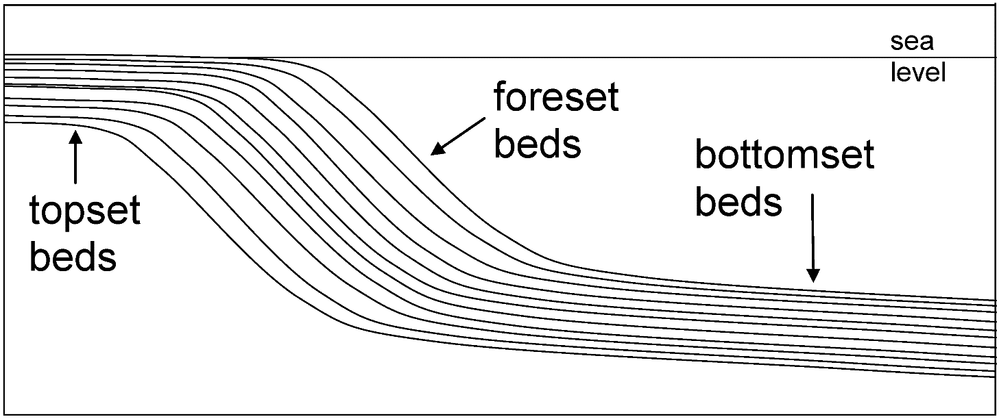
The foreset beds were deposited on higher-gradient slopes going down into deep water, so foreset beds consist of sediments deposited underwater in relatively high-energy conditions. The coarser sediments of turbidity currents – sand and gravel with cross-beds and graded beds – are common in the foreset beds.
The bottomset beds formed where turbidity currents, which originated higher on the delta, spread out onto the lower-gradient ocean floor in deeper water and lost their energy, and consist of fine sands, silts and clays, commonly in characteristic sequences of graded beds known as turbidites.
Evolution process and morphological characteristics of GBM delta system
The Ganges-Brahmaputra-Meghna (GBM) delta, also known as the Bengal Delta, is one of the world’s largest and most complex deltas, situated in the south of Bangladesh and the Indian state of West Bengal. It is formed by the confluence of the Ganges, Brahmaputra, and Meghna rivers as they empty into the Bay of Bengal. The evolution process and morphological characteristics of the GBM delta system are influenced by several factors, including sediment supply, river flow, tides, waves, and sea level changes. The delta has undergone various stages of development over geological time, resulting in distinct morphological features. Here is an overview of the evolution and morphological characteristics of the GBM delta system:
1. Evolution Process:
- Fluvial Dominance (Pre-Holocene): During the Pleistocene epoch, the GBM delta began to take shape with the primary influence of river processes. The Ganges and Brahmaputra rivers carried vast amounts of sediment from the Himalayas and deposited them along the Bengal shelf.
- Marine Influence (Holocene): As sea levels rose during the Holocene epoch, the advancing seas pushed the coastline inland, allowing seawater to penetrate further upstream. Tidal and marine processes began to play a significant role in shaping the delta, leading to the formation of tidal flats, tidal channels, and estuaries.
- Fluvio-Marine Transition (Late Holocene): The GBM delta experienced a fluvio-marine transition, characterized by the interaction of both riverine and marine processes. The distributaries of the rivers formed estuarine environments with extensive tidal networks, creating a complex and dynamic deltaic system.
- Human Influence (Historical Period): Human activities, such as deforestation, dam construction, and extensive agricultural practices, have influenced the delta’s morphology and hydrology. Human interventions have altered sediment transport, river flow, and water levels, leading to changes in the delta’s shape and floodplain patterns.
2. Morphological Characteristics:
- Delta Plain: The GBM delta has an extensive and flat delta plain that covers a vast area. This flat topography is the result of extensive sediment deposition by the rivers and the influence of tides.
- Active Distributaries: The deltaic region is characterized by an intricate network of active and distributaries of the Ganges, Brahmaputra, and Meghna rivers. These distributaries split into numerous channels that carry sediment and freshwater to the Bay of Bengal.
- Tidal Flats and Mangroves: The delta contains tidal flats and mangrove forests, particularly in the Sundarbans region. These areas experience the influence of tidal currents and support diverse ecological habitats.
- Estuaries and Intertidal Zones: Estuaries and intertidal zones are prominent features of the GBM delta system. They experience significant fluctuations in water levels due to the interaction of river flow and tidal forces.
- Bird’s-foot Deltas: The GBM delta exhibits bird’s-foot delta morphology, characterized by numerous elongated distributaries that resemble the toes of a bird’s foot. These distributaries are sensitive to shifts in river flow and sediment supply.
- Tidal Inlets: The delta features tidal inlets and embayments, which are subject to regular changes due to tidal currents and sediment deposition.
The GBM delta system is a dynamic and continuously evolving landscape, shaped by the interplay of riverine, tidal, and marine processes. The balance between sediment supply, river flow, tides, and sea-level changes contributes to the ever-changing morphology and ecological characteristics of the delta. The GBM delta plays a vital role in supporting rich biodiversity, providing essential resources, and serving as a critical habitat for various species, including the iconic Bengal tiger, making it an ecologically significant and sensitive region that requires careful management and conservation efforts.
- Discuss the process of delta formation and analyze the facies of delta with reference to Bangladesh (2015)
Process of Delta Formation:
The formation of a delta involves a complex interplay of various geological and geomorphological processes. It occurs when a river carrying sediment reaches a body of standing water, such as a sea, ocean, or lake. The process of delta formation can be summarized in the following steps:
- Erosion: The river erodes its source area (mountains or uplands) and transports sediment, including sand, silt, and clay, downstream.
- Sediment Transport: As the river enters the flatter and slower-moving water body, it loses its velocity and energy. Consequently, the sediment it carries settles out and is deposited at the river mouth.
- Deposition: The coarser sediments (sand and gravel) are deposited closer to the river mouth, while finer sediments (silt and clay) are carried further into the standing water and may settle out to form deeper offshore deposits.
- Channel Switching: Over time, the river may change its course, leading to the development of multiple distributaries. This channel switching contributes to the complexity of the delta.
- Accretion: As sediment continues to be deposited, the delta advances further into the standing water, gradually expanding the land area.
- Vegetation Growth: As the delta expands, vegetation, such as mangroves and other wetland plants, may establish themselves, further stabilizing the sediments and contributing to the formation of specific delta facies.
Facies of Delta in Bangladesh:
The delta of the Ganges-Brahmaputra-Meghna (GBM) river system in Bangladesh exhibits various facies, which are distinct sedimentary environments with specific characteristics. The GBM delta is classified into the following facies:
- Fluvial Facies: The upstream portion of the delta, close to the river’s source, consists of fluvial facies. These deposits primarily include coarse sediments like sands and gravels, transported by the river from the Himalayas.
- Tidal Flats and Mudflats: The delta’s central region is characterized by extensive tidal flats and mudflats, influenced by tidal currents and sedimentation. These areas are rich in fine-grained sediments, such as silt and clay, and often support mangroves.
- Intertidal and Subtidal Facies: The intertidal zone experiences periodic flooding and exposure due to tidal changes. The subtidal zone extends beyond the intertidal zone and contains deposits influenced by both marine and riverine processes.
- Estuarine Facies: The region where the river meets the sea exhibits estuarine facies, which represent a transitional environment with a mix of freshwater and marine influences. Estuarine facies include various sediments, such as sands, silts, and clays.
- Delta Front Facies: The delta front is the seaward part of the delta, and its facies consist of coarse-grained sediments, including sands and gravels, as well as interbedded finer-grained sediments.
- Prodelta Facies: The prodelta is the area beyond the delta front, characterized by fine-grained sediments, including muds and silts, deposited in deeper offshore settings.
The facies of the GBM delta are a result of the interplay between riverine, tidal, and marine processes, along with sea-level changes. Each facies represent a specific depositional environment with distinct sediment characteristics and plays a crucial role in shaping the delta’s landscape and supporting its diverse ecology. The deltaic region of Bangladesh is vital for agriculture, fisheries, biodiversity, and other ecosystem services, making it essential to understand and manage the various facies to ensure sustainable development and conservation of this unique environment.
Short
- Name the profiles of a nine-unit slope model. Discuss the factors controlling slope development. (2020)
Slope: Slope refers to the incline or relief of the surface of a soil area. The amount of inclineis commonly expressed in percent of slope, and reflects the amount of change of elevation over a given horizontal distance. It also refers to the ‘steepness’ of the line, also commonly known as rise over run.
Slope Classes
- Very Steep Slope – 1:1.7 (30-40 degree)
- Steep Slope – 1:3 (18-30 degree)
- Moderately steep Slope – 1: 6 (10-18 degree)
- Moderate Slope :1:12 (5-10 degree)
- Gentle slope – 1:29 (2-5 degree)
- Plain land- (<2 degree)
The nine-unit slope model, also known as the Universal Soil Loss Equation (USLE) or Revised Universal Soil Loss Equation (RUSLE), is used to estimate soil erosion rates based on several parameters related to slope, soil, land use, and climate. The USLE/RUSLE model consists of the following nine profiles or factors:
- Rainfall Erosivity (R): This profile represents the erosive power of rainfall and measures the amount and intensity of precipitation that can cause soil erosion. It considers factors such as rainfall depth, intensity, and duration.
- Soil Erodibility (K): The soil erodibility profile characterizes the susceptibility of the soil to erosion. It takes into account soil properties such as texture, organic matter content, permeability, and structure.
- Slope Length (L): Slope length refers to the distance over which water flows downslope before being collected. Longer slopes generally contribute to higher soil erosion rates.
- Slope Steepness (S): Slope steepness indicates the angle or gradient of the land. Steeper slopes tend to have higher erosion rates compared to gentler slopes.
- Cover and Management (C): This profile accounts for the vegetation cover and land management practices. It considers factors like crop cover, land use, tillage practices, and conservation measures.
- Support Practice (P): The support practice profile represents additional conservation practices implemented to reduce soil erosion. These practices include terracing, contour farming, and other soil conservation measures.
- Climate (Climatic Factor): The climate profile considers the erosive power of wind and its impact on soil erosion. It is relevant in areas where wind erosion is a significant factor.
- Vegetative Cover (Vegetative Factor): This profile considers the impact of vegetation on reducing soil erosion. It is particularly relevant in areas with significant wind or water erosion potential.
- Soil Cover (Cover Factor): The soil cover profile takes into account the amount of plant residues and surface cover on the soil, which helps protect against soil erosion by absorbing rainfall energy and reducing surface runoff.
These nine profiles are combined using mathematical equations within the USLE or RUSLE model to estimate the annual soil loss (A) from a specific land area. The model is widely used in soil conservation planning and land management to identify areas susceptible to erosion and to design appropriate erosion control measures.
Slope development refers to the process by which landforms and landscapes are shaped and modified over time due to various geological, climatic, and geomorphic factors. Several factors control slope development, and their interplay determines the characteristics of slopes and the landforms they create. The key factors controlling slope development are as follows:
- Geological Structure: The geological composition and structure of the underlying bedrock or substrate influence slope development. Different rock types have varying resistance to weathering and erosion, leading to the formation of different landforms, such as cliffs, hills, and valleys.
- Tectonic Activity: Tectonic processes, such as uplift, faulting, and folding, can create or modify slopes over geological time scales. Tectonic activity can lead to the formation of mountain ranges, plateaus, and rift valleys.
- Weathering and Erosion: Weathering processes, including physical, chemical, and biological weathering, play a significant role in slope development. Weathering breaks down rock and converts it into regolith, which can be further transported and deposited by erosion, shaping slopes over time.
- Climate and Precipitation: Climate and precipitation patterns influence the rate of weathering and erosion, affecting slope development. Regions with high rainfall are more prone to erosion, resulting in steeper slopes, while arid regions may experience slower erosion and develop gentler slopes.
- Vegetation and Plant Cover: Vegetation cover plays a vital role in slope stability and development. Plant roots bind soil and prevent erosion, reducing the rate of slope degradation. The type and density of vegetation influence slope characteristics.
- Human Activities: Human activities, such as deforestation, urbanization, mining, and construction, can significantly impact slope development. Human-induced changes to natural landscapes can accelerate erosion and alter slope morphology.
- Slope Materials: The type and properties of slope materials, such as soil, rock, and sediments, affect slope stability and morphology. Loose, unconsolidated materials are more prone to erosion and mass movement.
- Water and Drainage: The presence and movement of water on slopes play a crucial role in shaping landforms. Water can erode, transport, and deposit sediment, creating various slope features like gullies, valleys, and alluvial fans.
- Mass Movements: Mass movements, such as landslides, rockfalls, and slumping, can rapidly modify slopes and create new landforms. These events are often triggered by factors like heavy rainfall, seismic activity, or human activities.
- Time: Slope development is a process that takes place over long periods, often spanning millions of years. Time allows for weathering, erosion, and other geomorphic processes to shape and reshape slopes.
The interplay of these factors results in a wide range of slope characteristics, from gentle hills to steep cliffs and everything in between. Understanding the controlling factors of slope development is essential for land management, slope stability analysis, and the conservation of natural landscapes.
- What do you understand by lithostratigraphy? Discuss the steno’s law of stratigraphy. (2020)
Lithostratigraphy is a branch of stratigraphy, which is the study of rock layers and their arrangement in the Earth’s crust. Lithostratigraphy focuses specifically on the description, correlation, and classification of rock units based on their lithology (rock type) and the physical characteristics of the rocks. It involves the identification of rock formations, members, beds, and other lithostratigraphic units that are present in a specific area.
The main objectives of lithostratigraphy are to:
- Identify and Describe Rock Units: Lithostratigraphy involves the detailed description and characterization of rock units based on their lithology, texture, mineral composition, sedimentary structures, and other physical features.
- Correlate Rock Units: Lithostratigraphy allows geologists to establish relationships between rock units from different locations. By comparing the lithological characteristics of rocks, they can identify equivalent units and determine the lateral extent of specific rock layers.
- Establish Stratigraphic Nomenclature: Lithostratigraphy provides a standardized system of nomenclature for naming and classifying rock units. This system aids in communication among geologists and facilitates accurate representation of geological data in maps and reports.
- Reconstruct Geological History: By studying the succession of rock units and their relationships, lithostratigraphy helps geologists reconstruct the geological history of an area. It provides insights into past environmental conditions, sedimentary processes, and tectonic events.
- Assist in Resource Exploration: Understanding the distribution and characteristics of different lithostratigraphic units is essential in resource exploration, such as identifying potential oil and gas reservoirs, groundwater aquifers, and mineral deposits.
Lithostratigraphy is typically applied in sedimentary basins, where layers of sedimentary rocks are well-preserved and provide a wealth of information about the Earth’s geological history. It is an important tool in geological investigations and plays a fundamental role in constructing geological maps and models, understanding geological processes, and interpreting the Earth’s past environments and evolution.
Steno’s Law of Stratigraphy, also known as the Law of Superposition, is one of the fundamental principles in the field of stratigraphy, which is the study of rock layers and their relationships. The law was formulated by Danish scientist Nicolaus Steno (Nicolas Stenonis) in the 17th century and is a key concept in understanding the relative ages and sequences of different rock layers in geological formations.
Steno’s Law of Stratigraphy states the following:
Law of Superposition: In an undisturbed sequence of sedimentary rocks or layered volcanic rocks, the oldest layers will be at the bottom, and the youngest layers will be at the top. This means that as new sediments are deposited on top of older rocks, the new layers will be younger than the layers beneath them.
This law is based on the principle that in undisturbed environments, such as a sedimentary basin or the accumulation of volcanic ash, the deposition of sediment or volcanic material occurs layer by layer over time. Each new layer is deposited on top of the previous one, leading to the formation of a stratigraphic sequence.
The Law of Superposition allows geologists to determine the relative ages of rock layers and the sequence of events that have occurred in a particular area. By studying the arrangement of rock layers and their characteristics, geologists can interpret the history of sedimentation, past environmental conditions, and geological processes that have shaped the landscape.
It is important to note that the Law of Superposition assumes the absence of significant geological disturbances or tectonic events that might have overturned or folded the rock layers. In reality, geological processes such as folding, faulting, and erosion can disrupt the original order of rock layers, complicating the interpretation of the stratigraphy. Therefore, geologists use additional principles and techniques, such as cross-cutting relationships and radiometric dating, to refine their understanding of the geological history and unravel the complexities of Earth’s past.
- Karst topography
Karst topography, also known as karst landscape or karst terrain, is a distinctive type of landscape that forms in regions where soluble bedrock, such as limestone, gypsum, or dolomite, is prevalent. It is characterized by unique surface and subsurface features resulting from the dissolution of the soluble rock by natural processes, particularly by the action of water.
Key features of karst topography include:
Sinkholes: Sinkholes are depressions or holes in the ground formed by the collapse of underground voids or caverns. They occur when the soluble bedrock dissolves, leaving a void, and the overlying material eventually collapses into the void.
Caves and Caverns: The dissolution of limestone or other soluble rocks by acidic water creates extensive systems of underground passages, chambers, and caves. Some of these cave systems can be vast and complex.
Karst Springs: Karst springs are natural springs that discharge water from underground caverns or conduits. The water originates from precipitation that percolates through the soluble rock and collects underground before resurging at the spring.
Uvalas and Poljes: Uvalas are large closed depressions in karst landscapes, often formed by the coalescence of sinkholes. Poljes are flat, elongated, and often large depressions that result from the subsidence of soluble rocks.
Karst Towers and Cones: In regions with thick layers of soluble rock, isolated limestone towers or cone-shaped hills, known as karst towers or cones, can form due to selective erosion of the rock.
Karst Valleys: Karst landscapes can have unique valley formations called karst valleys, which result from the dissolution of limestone along joints or fractures.
Karst Pavements: In areas where the bedrock has been extensively dissolved, the landscape may feature a karst pavement, a rocky surface with exposed limestone blocks.
Karst topography is primarily shaped by the chemical weathering and dissolution of the soluble bedrock by carbonic acid, which forms when rainwater absorbs carbon dioxide from the atmosphere or the soil. Over time, this dissolution creates an intricate network of underground voids and conduits that give rise to the surface features.
Karst landscapes have significant hydrological implications, as water can quickly drain into the subsurface through sinkholes and caves, leading to the formation of underground rivers and complex aquifer systems. These features make karst areas important for water supply and pose challenges for resource management and engineering projects due to potential subsidence and sinkhole formation.
Karst topography is found in various parts of the world and is especially prominent in regions with extensive limestone or other soluble bedrock formations, such as the karst regions in the Balkans, China, the Caribbean, and the Yucatán Peninsula in Mexico, among others.
- What is Landslide? (2014) Mention the common types of landslides. Discuss the causes of landslide with reference to Bangladesh. (2020)
A landslide is a geological phenomenon characterized by the movement of a mass of rock, soil, and debris down a slope or hillside under the influence of gravity. Landslides occur when the forces that hold the slope materials together are overcome, leading to the downslope movement of the materials.
Landslides can vary in size, speed, and type, depending on several factors such as the type of slope material, the angle of the slope, the presence of water, and the triggering mechanisms. They can range from small, slow-moving slumps to large, rapid debris flows with devastating consequences.
Landslides can be triggered by various factors, including heavy rainfall, earthquakes, volcanic activity, human activities (such as construction and deforestation), and changes in groundwater levels. They can occur in various geological settings, from mountainous regions to coastal areas, and can have significant impacts on the environment, infrastructure, and communities.
Landslides are a type of mass wasting, which refers to the downslope movement of rock, soil, and debris under the influence of gravity. Various factors, such as geological, hydrological, and anthropogenic, can trigger landslides. Common types of landslides include:
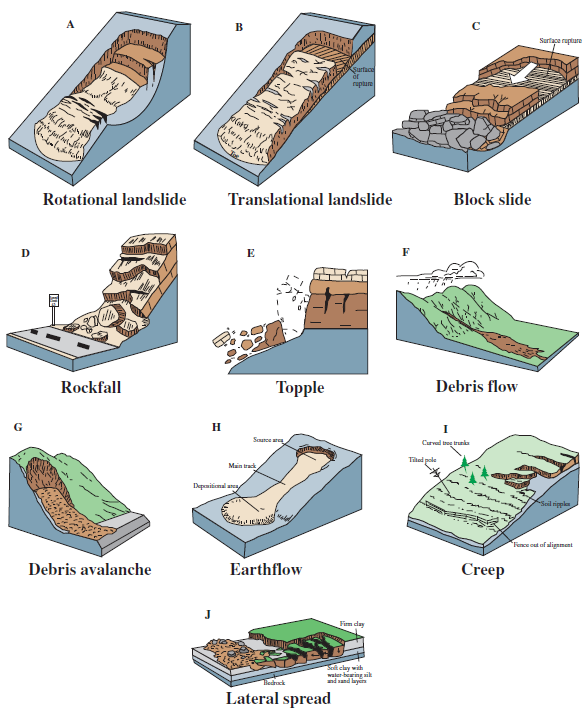
- Rockfalls: Rockfalls are sudden and rapid movements of individual rocks or large blocks of rock from steep slopes or cliffs. They can be triggered by weathering, seismic activity, or the undercutting of slopes by natural processes or human activities.
- Slides: Slides are characterized by the movement of a mass of soil or rock material along a well-defined surface. Slides can be further classified based on the nature of the sliding surface, including rotational slides, translational slides, and compound slides.
- Debris Flows: Debris flows, also known as mudflows or lahars (when volcanic material is involved), are rapid and highly destructive flows of water-saturated debris, such as mud, rock fragments, and vegetation, down steep slopes or canyons.
- Slumps: Slumps involve the movement of a cohesive block of soil or rock material along a curved, concave sliding surface. The movement is characterized by a rotational motion and is common in unconsolidated or clay-rich materials.
- Earthflows: Earthflows are slow-moving, viscous flows of fine-grained material, such as clay and silt, which can occur in humid environments. They often exhibit characteristic lobate or tongue-like shapes.
- Creep: Creep is a slow and gradual downslope movement of soil or regolith caused by the expansion and contraction of particles due to freeze-thaw cycles or wetting-drying processes.
- Landslide Complexes: Landslide complexes involve a combination of different types of landslides occurring simultaneously or in succession within a particular area.
- Debris avalanche: This is a variety of veryrapid to extremely rapid debris flow
It’s important to note that landslides can occur in various geological settings and can be influenced by factors such as topography, geology, climate, vegetation, water content, and human activities. Landslides can have significant impacts on the environment, infrastructure, and human lives, making their identification, monitoring, and management essential for hazard mitigation and disaster risk reduction.
Causes of Landslides in Bangladesh:
- Geological Factors: Bangladesh is situated in a tectonically active region, prone to seismic activity and tectonic movements. Earthquakes can trigger landslides by destabilizing slopes and causing rockfalls or slope failures.
- Heavy Rainfall: Bangladesh experiences heavy monsoonal rainfall, especially during the wet season. Prolonged and intense rainfall saturates the soil, increasing its weight and reducing its strength, leading to landslides.
- Steep Slopes: Many regions in Bangladesh, particularly in the Chittagong Hill Tracts and the Sylhet region, have hilly and steep terrain. The combination of steep slopes and heavy rainfall makes these areas susceptible to landslides.
- Deforestation and Land Use Changes: Deforestation and land use changes, including improper agricultural practices and urbanization, can lead to the removal of vegetation cover and destabilize slopes, increasing the risk of landslides.
- Construction and Excavation: Human activities, such as construction, road building, and excavation, can alter the natural topography and slope stability, potentially triggering landslides.
- Climate Change: Climate change can lead to shifts in precipitation patterns, more intense storms, and increased rainfall variability. These changes can further exacerbate landslide hazards in vulnerable areas.
Consequences of Landslides in Bangladesh:
- Loss of Lives and Property: Landslides can result in fatalities and cause extensive damage to buildings, infrastructure, and agricultural land, leading to significant economic losses.
- Displacement and Homelessness: Landslides can force people to evacuate their homes, leading to temporary or permanent displacement of communities.
- Infrastructure Damage: Roads, bridges, and other infrastructure can be severely damaged or destroyed by landslides, hindering transportation and access to remote areas.
- Impact on Agriculture: Landslides can destroy crops and agricultural land, affecting food security and livelihoods of rural communities.
- Environmental Degradation: Landslides can cause erosion and sedimentation in rivers and water bodies, leading to water quality issues and disruption of aquatic ecosystems.
- Increased Risk of Flooding: Landslides can block rivers and streams, leading to the formation of landslide dams. If these dams collapse, they can release large volumes of water downstream, causing flash floods.
- Geological Hazards: Landslides can trigger other geological hazards, such as debris flows and dam collapses, further compounding the risks.
To mitigate the impact of landslides in Bangladesh, measures such as proper land-use planning, slope stabilization, afforestation, early warning systems, and community awareness programs are crucial. Understanding the underlying causes and consequences of landslides is essential for implementing effective measures for hazard prevention, disaster preparedness, and sustainable development in landslide-prone regions.
- Define Palaeo-Geomorphology. Discuss the principle of C44 Dating and its application in reconstruction of palaeo-environemnt. (2015) Explain how bio-stratigraphy can be used as a technique to reconstruct the palaeo-environment. (2014) (2019) (2021) Discuss different techniques to reconstruct palaeo environment. (2017)
A branch of geomorphology concerned with the study of ancient topographic features now either concealed beneath the surface or removed by erosion. Under the term palaeogeomorphology are grouped all geomorphological phenomena which are recognizable in the subsurface
According to William D. Thornbury,
“A branch of geomorphology which has not received the attention it merits that is the study of ancient land forms”
Palaeogeography(or paleogeography) is the study of historical geography, generally physical landscapes. Palaeogeography can also include the study of human or cultural environments. When the focus is specifically on the study of landforms, the term palaeogeomorphology is sometimes used instead.
Reconstruction of Paleo environment:
Reconstructing the past may be defined as the process by which we use various scientific methods to drive the environmental conditions which used to prevail in the past. Due to the scarcity of instrumental climate records prior to the century, estimates of global climate variability during past centuries must rely upon indirect “proxy” indicators. A proxy indicator is a local record that is interpreted using physical or biophysical principles to represent some combination of climate or environmental-related variations back in time. Some commonly used techniques help to know past climate and also help reconstruct the paleo-geomorphic environment. There are several methods of reconstruction of the past environment:
1) Lithostratigraphic methods- a) Law of superposition b) Troels smith scheme c) Paleo-magnetism
2) Bio-stratigraphic methods – a) Pollen analysis b) Diatom Analysis
3) Radio-carbon Dating (C14)
4) Miscellaneous a) Ice Cores b) Lake and ocean sediment c) Borehole Measurements d) Tree-rings (Dendrochronology)
1) Lithostratigraphic Methods:
In lithostratigraphy rock units are considered in terms of the lithological characteristics of the strata and their relative stratigraphic positions. The relative stratigraphic positions of rock units can be determined by considering geometric and physical relationships that indicate which beds are older and which ones are younger. The units can be classified into a hierarchical system of members, formations and groups that provide a basis for categorising and describing rocks in lithostratigraphic terms.
An understanding of stratigraphy is useful for understanding when and how life originated on Earth, as well as for studying evolution and historical changes in Earth’s ecosystems. Potential careers that benefit from an understanding of stratigraphy include palaeontologists, archaeologists, and soil scientists.
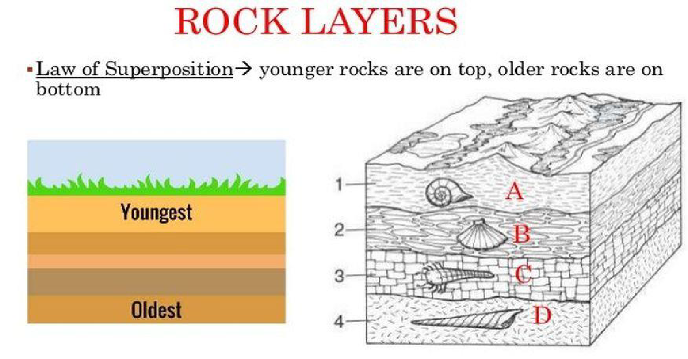
Different methods of Lithostratigraphy:
- a) Law of superposition: Established by Nicolas Steno, that stated, a basic law of geochronology, stating that in any undisturbed sequence of rocks deposited in layers, the youngest layer is on top and the oldest on bottom, each layer being younger than the one beneath it and older than the one above it. This law is used for relative measuring of rock age.
- b) Troels Smith Scheme: In litho-stratigraphic analysis, It is universally accepted approach of analysis. Until 1955, there had been no consistency among the workers in stratigraphic description. Troel-smith attempted to overcome these difficulties by divising a scheme for recording the physical characteristics of an unconsolidated sediment. The scheme is a environmental approach based on field study of different elements. It basically defines 3 elements that should or specified for each layer of stratigraphy identified. These are:
- 1) The components
- 2) The degree of humification
- 3) The physical properties of sediment layer
- ✓Components: A layer may contain one or more components like:
- 1. Turfa (roots of woody and herbaceous plants)
- 2. Detritus (Fragments of leaves,wood,stems, branches)
- 3. Argilla (Minerogenic sediment like silt,clay)
- 4. Grana (Macroscopic particles like sand, gravel)
These components help to differentiate one layer from another and also reflects characteristics of that respective time when the strata were layered.
Degree of Humification
The degree of humification indicates the degree of decomposition of the macrofossils that can be observed. It is estimated on five points scale where) on the scale indicates that the plant structure is unhumified and 4 indicates more or less complete humification.
Physical properties of any layer include:
- Degree of darkness(nig)
- Stratification (srt)
- Elasticity (elas)
- Dryness (sicc)
- The sharpness of the upper boundary (los)
- c) Palaeomagnetism: Scientists can study the history of Earth’s magnetic field by using Earth’s rocks as records. Palaeomagnetism is the study of magnetic rocks and sediments to record the history of the magnetic field. Some rocks and materials contain minerals that respond to the magnetic field. So, when rocks form, the minerals align with the magnetic field preserving its position. It’s called rock magnetism when rocks record the position of the magnetic field. The magnetic signature of the rocks allows paleomagnetic to date the rocks and map the position of the field at the time of their formation.
Palaeomagnetism also provides evidence to support theories in plate tectonics. Because the ocean floor is mostly composed of basalt, an iron-rich substance containing minerals that align with the magnetic field, they record the alignment of the magnetic fields surrounding oceanic ridges. Scientists studied the magnetic signatures of the rocks on the ocean floor and noticed some recorded opposite directions for magnetic field lines even though they were side by side. This likely occurred because magma rose from the ridges in the ocean floor and formed new rock recording a more recent alignment of the magnetic field while pushing old rock with more outdated magnetic records further from the ridge.
2) Bio-stratigraphic method: Biostratigraphy is the branch of stratigraphy which focuses on correlating and assigning relative ages of rock strata by using the fossil assemblages contained within them. Biostratigraphic method represents the analysis of biological evidence from earth’s material. It includes:
- a) Pollen analysis: The technique was initiated by by Swedish geologist Kennart Von post in 1916. Pollen analysis is a scientific method that can reveal evidence of past ecological and climate changes: it combines the principles of stratigraphy with observations of actual (modern) pollen-vegetation relationships in order to reconstruct the terrestrial vegetation of the past. It is a type of environmental archaeology in which microscopes are used to analyse the range of plant pollens present in archaeological layers: these can tell us what crops, vegetation or ground cover were likely to have been present when a layer was deposited.
- b) Diatom Analysis: Diatoms (Bacillariophyceae) are microscopic unicellular algae abundant in almost all aquatic habitats; they are key components of food webs in nearly all freshwater and saline environments. The evidence of diatom in lithological sequence demonstrate the past marine history of that area.
3) Radio-carbon Dating (C14):
Radiocarbon dating is a method that provides objective age estimates for carbon-based materials that originated from living organisms. 1 An age could be estimated by measuring the amount of carbon-14 present in the sample and comparing this against an internationally used reference standard.
Carbon dating is based upon the decay of 14C, a radioactive isotope of carbon with a relatively long half-life (5700 years). While 12C is the most abundant carbon isotope, there is a close to constant ratio of 12C to 14C in the environment, and hence in the molecules, cells, and tissues of living organisms. This constant ratio is maintained until the death of an organism, when 14C stops being replenished. At this point, the overall amount of 14C in the organism begins to decay exponentially. Therefore, by knowing the amount of 14C in fossil remains, you can determine how long ago an organism died by examining the departure of the observed 12C to 14C ratio from the expected ratio for a living organism. Radiocarbon dating is essentially a method designed to measure residual
radioactivity.
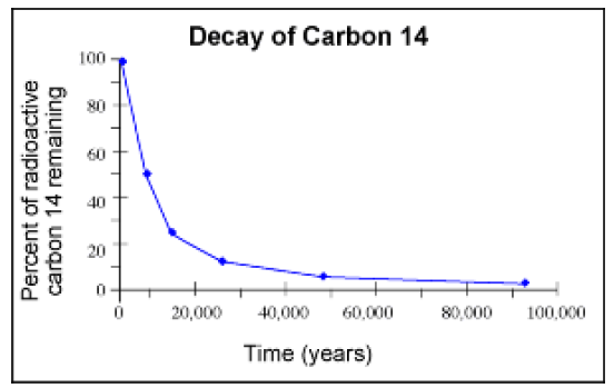
Decay of radioactive isotopes:
Radioactive isotopes, such as 14C, decay exponentially. The half-life of an isotope is defined as the amount of time it takes for there to be half the initial amount of the radioactive isotope present. For example, suppose you have N0 grams of a radioactive isotope that has a half-life of t* years. Then we know that after one half-life (or t* years later), you will have grams of that isotope.
t* years after that (i.e. 2t* years from the initial measurement), there will be grams.
3t* years after the initial measurement there will be grams, and so on.
We can use our our general model for exponential decay to calculate the amount of carbon at any given time using the equation, N (t) = N0e kt.
4) Miscellaneous:
- a) Ice cores: Ice cores from polar regions and mountain glaciers provide several indicators of past climates, including stable isotopes, the fraction of melting ice, accumulation rates, concentration of different salts and acids or the amounts of pollen or trace gases.
- b) Lake and ocean sediments: Annually laminated (varved) lake sediments also provide high-resolution records of paleo-environment. Three main climate variables may influence lake varves: Summer temperature, winter snowfall and rainfall. Moreover to sedimental studies, lake sediments can be analysed from a variety of approaches: isotope analysis, chemical analysis, pollen records and diatom analysis.
- c) Borehole measurements: Relatively recent methodology, that attempts to provide a direct estimate of ground surface temperatures under certain simplifying assumptions about geothermal properties of the earth. Borehole estimations of temperature are probably most useful for climate reconstructions over the last five centuries.
- d) Tree-rings: Also known as dendrochronology that is based on the fact that tree growth is often limited by a variety of environmental factors, which may vary depending on the area studied. For example, in arid and semi-arid areas precipitation is the main factor limiting tree growth, whereas in colder regions temperature becomes the most limiting factor.
- Discuss the importance of studying paleo-geomorphology in the context of Bangladesh. (2018)
Studying paleo-geomorphology in the context of Bangladesh is of significant importance due to its potential to provide valuable insights into the region’s geological and environmental history. Paleo-geomorphology involves the investigation and reconstruction of past landscapes, landforms, and processes that shaped the Earth’s surface in the past. In the case of Bangladesh, understanding paleo-geomorphology offers several key benefits:
- Tectonic Evolution: Studying paleo-geomorphology can help unravel the tectonic history and geodynamic processes that have influenced the formation of Bangladesh’s landforms. It can shed light on past movements of tectonic plates, uplift events, and the development of mountain systems that contributed to the present landscape.
- Sea-Level Changes: Bangladesh is a low-lying deltaic region highly susceptible to sea-level changes. Paleo-geomorphological investigations can reveal past sea-level fluctuations and provide information about the responses of the deltaic systems to changing sea levels. This knowledge is vital for understanding future climate change impacts on coastal regions.
- Paleoenvironmental Reconstructions: Paleo-geomorphology helps reconstruct past environmental conditions, including climate, vegetation, and hydrological patterns. This information is crucial for understanding natural variations in ecosystems and the impacts of human activities on the environment.
- Sedimentary History: By studying paleo-geomorphology, researchers can identify past sedimentary environments and decipher the sedimentary processes that led to the formation of various rock layers and landforms. This information is essential for resource exploration, including the identification of potential aquifers and mineral deposits.
- Coastal Erosion and Land Loss: Coastal erosion and land loss are critical issues for Bangladesh. Studying paleo-geomorphology can help assess the long-term rates and patterns of coastal erosion, contributing to better coastal management and the development of effective strategies for mitigating land loss.
- Paleoseismology: Bangladesh is situated in a seismically active zone. Paleoseismological studies can provide information about past earthquake events, helping to assess the seismic hazard and potential recurrence of major earthquakes in the region.
- Geological Hazards and Disaster Mitigation: Understanding past geological events and their impacts can aid in hazard assessment and disaster management. Information about past floods, cyclones, and tsunamis can help improve resilience and preparedness for future events.
- Archaeological and Cultural Heritage: Paleoenvironmental studies can also be valuable for understanding the historical context of human settlements, ancient civilizations, and cultural heritage in the region.
Incorporating paleo-geomorphological research into Bangladesh’s geoscientific studies enhances our understanding of the country’s geological past and can inform sustainable land-use planning, infrastructure development, and environmental management. By recognizing past geological events and processes, Bangladesh can make informed decisions to address present challenges, adapt to future changes, and protect its natural resources and cultural heritage.
- Define hydrograph.
A hydrograph is a graphical representation of the flow or discharge of water in a river or stream over a specific period of time. It shows how the flow of water changes in response to rainfall, snowmelt, or other factors that influence the water level in the river. Hydrographs are essential tools in hydrology and are used to analyze and interpret the behavior of river systems, understand hydrological processes, and assess flood events.
Key components of a hydrograph include:
- Time: The horizontal axis of the hydrograph represents time, usually in hours or days. The hydrograph shows how the flow of water in the river changes over a specific time period, typically during a rainfall event or a period of snowmelt.
- Discharge: The vertical axis of the hydrograph represents the flow or discharge of water in the river, typically measured in cubic meters per second (m³/s) or cubic feet per second (cfs). Discharge is the volume of water passing a given point in the river over a unit of time.
- Hydrograph Components: Hydrographs typically have two main components: the rising limb and the falling limb. The rising limb shows the rapid increase in discharge as the river responds to rainfall or snowmelt. The falling limb shows the gradual decrease in discharge as the river returns to its base flow conditions after the rain or snowmelt event has passed.
Hydrographs are used for various purposes, including:
- Flood Prediction and Management: Hydrographs help predict and analyze river flow during heavy rainfall events, aiding in flood forecasting and management.
- Hydrological Studies: Hydrographs provide valuable data for studying the hydrological behavior of river basins, including understanding how different watersheds respond to rainfall events.
- Water Resource Management: Hydrographs are used to assess the availability and variability of water resources in river systems, which is essential for water supply planning and water resource management.
- Environmental Monitoring: Hydrographs can help monitor the impact of human activities or climate change on river flow and water levels, contributing to environmental assessments and conservation efforts.
Hydrographs are an indispensable tool for hydrologists and water resource professionals, providing crucial information to support decision-making and effective management of water resources and flood risks.
- What is mass movement?
Mass movement, also known as mass wasting, refers to the downslope movement of rock, soil, and debris under the influence of gravity. It is a natural process that occurs on slopes and can be triggered by various factors, including geological, climatic, and human activities. Mass movements can range from slow, gradual processes to rapid, catastrophic events, and they play a significant role in shaping the Earth’s surface.
Gravity as the Driving Force: The primary driving force behind mass movements is gravity. When the forces holding the materials on a slope are overcome by gravity, the materials start moving downslope.
Types of Mass Movements: Mass movements are classified based on the type of material involved and the nature of movement. Common types of mass movements include landslides (rockfalls, rockslides, debris flows), slumps, earthflows, creep, and avalanches.
Factors Influencing Mass Movements: Several factors can trigger or influence mass movements, including heavy rainfall, snowmelt, earthquakes, volcanic activity, deforestation, human excavation, and changes in slope stability due to natural weathering processes.
- Models in geomorphology (2019)
In geomorphology, models are simplified representations or conceptual frameworks used to understand and explain the processes that shape the Earth’s surface and the formation of various landforms. These models help scientists and geographers predict how landscapes may evolve over time and provide insights into the interactions between different factors influencing landforms. Several types of models are used in geomorphology, each focusing on specific aspects of landscape development. Here are some common models in geomorphology:
- Fluvial Models: Fluvial models focus on river processes and the formation of landforms in river environments. For example, stream power models examine the relationship between stream discharge, sediment transport, and erosion to predict channel behavior and the formation of river valleys.
- Eolian Models: Eolian models deal with wind-driven processes and landforms such as sand dunes, loess deposits, and desert landscapes. These models consider factors like wind speed, sediment supply, and surface roughness to understand dune formation and migration.
- Glacial Models: Glacial models are used to study the behavior of glaciers and ice sheets, as well as the processes of erosion, transportation, and deposition associated with glacial landforms such as moraines, cirques, and drumlins.
- Karst Models: Karst models focus on the dissolution of soluble rocks and the formation of karst landscapes, including caves, sinkholes, and underground drainage systems. These models consider factors like rock type, water acidity, and flow rates.
- Tectonic Models: Tectonic models explore the impact of plate tectonics on landscape evolution, including the formation of mountain ranges, faulting, and folding. These models consider the movement of Earth’s lithospheric plates and their interactions.
- Process-Response Models: Process-response models link landscape-forming processes (e.g., erosion, sediment transport) with landform responses. These models often involve feedback loops to understand how changes in one component of the system affect others.
- Numerical Models: Numerical models use mathematical equations and computer simulations to replicate complex geomorphic processes. These models are used for detailed analyses of specific landscapes and allow for predictions under various scenarios.
- Geomorphic Evolution Models: Geomorphic evolution models aim to reconstruct the long-term development of landscapes and landforms by considering the interactions of different processes over geological time scales.
- Steady-State Landscape Models: These models assume that landscapes reach a dynamic equilibrium over time, with erosion and uplift rates balancing out to maintain a relatively constant surface form.
- Threshold Models: Threshold models investigate how changes in external factors, such as climate or human activities, can trigger sudden shifts in landscape form or landform stability.
Geomorphological models are valuable tools for understanding the complexities of landscape evolution and for making predictions about future changes. However, it is essential to recognize that models are simplifications and representations of real-world processes and that natural landscapes can be influenced by a wide range of factors working together in complex ways. Therefore, models should be used with caution and validated through field observations and empirical data.
- Nu Admission
- Bangladesh Police Job Circular
- Bangladesh army Job circular
- PDF Book – Class | Five | | Six | Seven | | Eight | | Nine |
- Editable Certificate Format